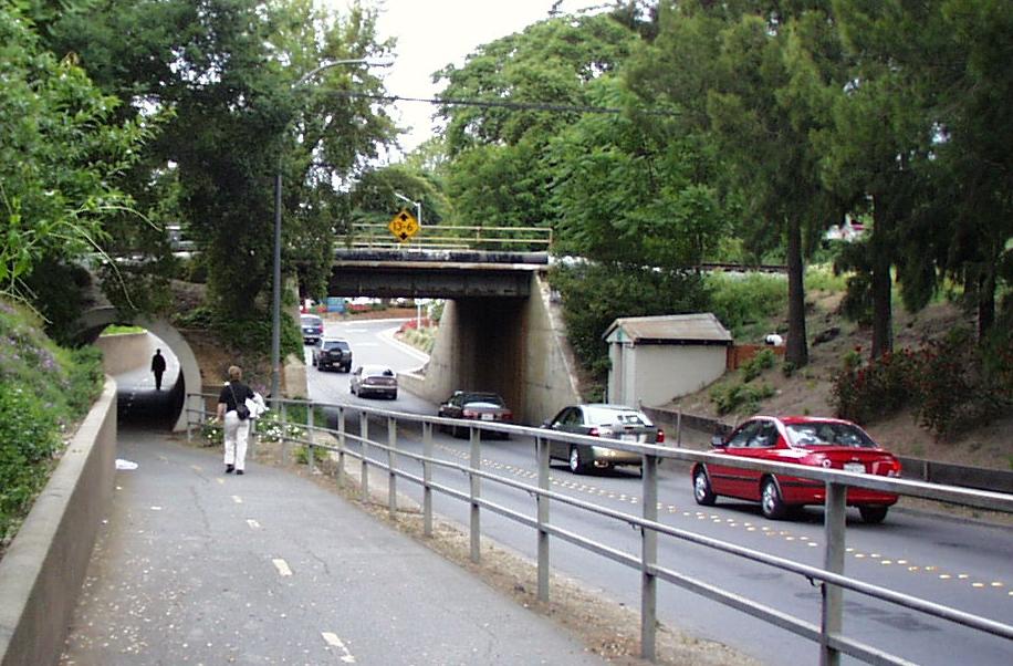
As I looked through the Sterling Apartments Final EIR, one of things that struck me was a typical complaint that commenters have made about most projects in Davis – the impact of the development on traffic. In fact, I would wager that traffic impacts were a key consideration in why Nishi was narrowly voted down last June.
After reading through the responses to the Draft EIR and some of the notations from the 2001 General Plan and the General Plan Transportation Element, there seems to be a disconnect between community concerns about traffic impacts and city policies regarding level of service requirements.
In background material provided by the city, prior to 2001, the LOS (Level of Service) standards in the General Plan were: “C” on new streets and “D” on existing streets. However that changed in the 2001 General Plan Mobility Element adopted in 2001, which reduced the standards to: “D” during non-peak hours, “E” during peak hours, and “F” during peak hours in the Core Area.
Then in the 2013 Transportation Element, the LOS standards changed to Standard TRANS 2.1d: Where the LOS for major intersections is D during non-peak traffic hours, E during peak traffic hours, F during peak traffic hours in the Core Area and Richards Boulevard/Olive Drive area, and F during peak traffic hours in other areas if approved by City Council.
A Level of Service of D produces between a 35 to 55 second delay at a signalized intersection: “Approaching unstable flow (tolerable delay, occasionally wait through more than one signal cycle before proceeding).” LOS E produces a 55 to 80 second delay depicted by an “unstable flow” or “intolerable delay.”
Finally, Level of Service (LOS) F means more than an 80 second delay, or a “forced flow” or “jammed.”
The Final EIR has a good description of the rationale for allowing LOS F in the core area. First, “High LOS standards to achieve low levels of congestion are not necessarily linked to urban vitality and quality of life.” Second, “The reduced standards would be consistent with community objectives of avoiding road widenings which would be unacceptable in terms of community character.” Third, “High LOS standards make infill development more difficult because infill uses the capacities of streets and may cause traffic volumes to approach the capacities of streets.” Finally, “Allowing higher levels of congestion may encourage alternative modes of transportation.”
The EIR notes, “Davis streets shall have no more than four through automobile lanes, plus a single left-hand turning lane, even if this requirement reduces LOS. Additional turning lanes may be added for safety or design considerations.”
The implications of allowing LOS F in the Core Area were analyzed in the General Plan EIR when the policy was first adopted. They note: “The effects of the City’s LOS standards will be to limit the number of lanes that planning area roadways could add (no more than four) to accommodate traffic increases associated with new development. However, this increase is offset to some small extent by other policy changes in the General Plan Update.”
The city has placed an emphasis on infill development “in areas proximate to employment, entertainment, retail, and activity centers rather than increasing roadway capacity and, thus, road width. Encouraging infill development reduces the sprawl-related impacts associated with increased vehicle trips and vehicle miles traveled (VMT).”
They further note: “The City’s policy determination to allow LOS F in the Core Area differentiates the Core Area from other parts of the City that are less dense and may be less accessible to transit. While traffic congestion may increase in the Core Area, the City has determined that this congestion is acceptable. Traffic delay may be an inconvenience to drivers, but these delays would not result in a physical environmental impact. Inconvenience is preferable to the significant environmental impacts and adverse impacts to residences and businesses that are caused by widening roadways to accommodate increased traffic and by increased VMT.”
All of this is interesting, but there are a few thoughts here that we might wish to further consider in future efforts.
First, the last paragraph suggests that traffic delay is preferable to increased VMT. But do we know if this is actually true? If cars are idling because of traffic congestion, how long before that begins to offset the benefits of compact city design and density?
Second, the community has largely come to the conclusion that further development on the periphery, at least at this time, is largely off the table. That is not to say that the citizens won’t in the future, even the near future, approve a peripheral development, however, the fact is that since Measure J passed in 2000, the only development we might consider peripheral to come into being is the Cannery, which was exempt from a vote.
The offset from having more peripheral development and impact on agricultural land is the increased pressure to put more density near the core area – which comes into conflict with people wishing to avoid traffic impacts.
Finally, I wonder how much of a discussion the city policy on Level of Service has actually engendered in the public. I have reached out to some who were involved in the discussion back in 2001 to understand this better.
The city justified the allowance of LOS F in the Core Area based on four considerations, as mentioned earlier.
First they note the lack of link to urban vitality and quality of life – and yet we see in the discussions of new infill development or Nishi, traffic impacts are at the top or near the top. So it would be interesting to dive into the basis for that justification.
Second, the community has objected to road widening. We have in the past noted that the community would rather have traffic congestion than widening the Richards Tunnel. Of course, that was not the only consideration there as many, myself included, believe that widening the Richards Tunnel simply shifts where the congestion occurs.
In fact, I have argued in the past, and continue to believe, that Richards Tunnel is not the actual bottleneck. Proof of that is that passing through the tunnel does not alleviate peak hour traffic congestion, which continues along the main route of 1st Street and even down B Street.
Despite this seemingly conscious choice of the voters, traffic has been used as a rationale to restrict future development.
Third, “High LOS standards make infill development more difficult because infill uses the capacities of streets and may cause traffic volumes to approach the capacities of streets.” This is ironic because, in effect, traffic considerations have been used to argue for limiting density of new infill.
Finally, they note that congestion may encourage alternative modes of transportation. And yet there seems to be the belief that alternative transportation use has decreased, at least among the permanent residents in Davis. It would be interesting to see a study to see if there is a causal relationship here – at the very least.
This dovetails with a conversation I had this week regarding the downtown and the concern that the lack of parking and the seeming vilification of those using automobiles for transportation has led to a Davis that serves only local people shopping in the locally-operated stores.
There is of course dispute in that view, but it remains a topic of conversation.
The bottom line for me is that the city has set a level of service for streets that seems at odds with what people want when it comes to discussions of traffic impacts of development. How was that standard decided and is the public agreeable to it?
—David M. Greenwald reporting

“Finally, they note that congestion may encourage alternative modes of transportation.”
Let’s flip that idea and see how it looks.
Rather than building more road lanes to accept more automobiles caused by the influx of more people, we divert these auto-enhancement funds to alternative transportation capability. More and wider bike lanes, lanes, a vehicle lane dedicated exclusively to public forms of transportation.
We allow a major development to be built, but plan it to be a “mini-city unto itself.” Replace the garage in these new homes with a large multi-purpose room.
The appeal and popularity of the Core Area in Davis is that all the amenities residents want are within walking distance. Some of these blessed folks go for days or weeks on end and never have the need to drive a car (if they even have one). So, build another Core Area on a city fringe, and mimic all the essential commercial shopping and dining needs found in the original.
So instead of a central core, you have a group of pods, where the neighborhoods are self-contained work-live-play.
A much smarter approach to development, but we continue to be wedded to the foolish notion of protecting the downtown at the expense of everything else. Image if the Target site had been developed as mixed use with retail, commercial and high-density residential all situated in the same location. Or had we developed all of our neighborhood centers with the same approach? We would have a much more robust retail sector in town had we not listened to the siren calls to ‘save the downtown property owners from competition’ and ‘don’t build more apartments.’ We also would have fewer people fighting to drive downtown because we would have options for retail and entertainment in other sections of the town.
It probably wouldn’t look a lot different than it does.

I guess so, at least from a satellite or airplane. 🙂
Commercial does not always mix well with residential, especially big-box type commercial or industrial/research developments.
Also, there’s a reason that these types of developments are situated on or near busy frontage roads, railroad lines and freeway exits. (These aren’t “downtown boutique” businesses.)
When you lack imagination, all you can do is repeat the choices of the past, convinced that they are your only options.
Mark:
Not sure what’s “wrong” with the current large-scale commercial developments in that location. Your statement implies that a mistake was made. (I suspect that you supported Target, given your other statements.) Maybe some granny units above the loading dock (or in the parking lots) would be better?
Didn’t we just “lose” Whole Foods, perhaps partly because of its inconvenient, difficult-to-access and park location?
Don – Please identify even one mixed-use building in your picture.
When I consider mixed use, I am thinking high-density residential over retail or commercial, with the result looking nothing like what currently exists in the picture that you posted. We created this expanse of wasted space because of the backward-looking zoning regulations that were designed to protect downtown property owners. Too bad we have had such a paucity of imagination when it comes to development in this town.
We have a Target store at that site because two sitting council members went to Target and solicited them to come to Davis, shepherded their project through the planning process, pushed the council to a majority vote, and pushed hard for the project in a public vote. Those council members didn’t want a mixed use project, didn’t have any interest in anything other than exactly what is there. If there is any paucity of imagination, speak to those council members.
Your comment referred to a “mixed use site.” Not “mixed-use buildings.” I think mixed-use buildings can be very successful and effective, but seem unlikely on peripheral sites. And they weren’t the development model Target and other big-box stores were using at that time.
Mark:
Is “mixed use” the new buzz-word, now (for those who constantly try to convince everyone of some “internal need”, to be solved via more development)?
All retail/commercial has to be “mixed-use”, these days? That’s “always” the best type of commercial, now? Even with “big box” retail stores?
And, it doesn’t create any problems regarding parking, access, and differing needs of commercial, vs. residential development? (You know, some of the same type of access and parking problems that might have contributed to the demise of Whole Foods?)
As a side note, I’ve found that some “pro-development types” have criticized the Cannery for being “too dense”, “useless urban farm”, etc.)
Ron…
Are you serious, or ‘fishing’?
Mixed use is an old term, and characteristic of older urban areas… the concept was/is, the opportunity for live-work (a much newer term), and efficient use of urban space, with retail/commercial on ground level, residential above.
The concept is probably over 500 years old, frequently found in Europe, and most older parts of American cities… you can see it in Sacramento, San Francisco, etc.
Another advantage to the concept, besides live/work in urban areas, is it means “eyes/ears on the ground” 24/7/365, as to crime particularly theft/vandalism. That declined when the trend was for sprawl, and those dwelling units could trend to be “flop-houses”, or SRO dwelling units…
So again, as to mixed use, are you serious in your question of the concept? Or just trying to be…
Howard:
Regarding “mixed use”, I am suggesting the developers (and those who support them) are sometimes “latching onto” the term, essentially as an excuse to develop more. Even in situations where it might not be the best use of land, or provide the optimum benefit (financially, and otherwise) for existing residents, current and proposed businesses, and the city itself.
To some degree, a similar situation is also occuring with other terms (e.g., “smart growth”, and other “green” terminology/practices). Developers will sometimes adopt (and exploit) these terms/practices, in an attempt to convince others of the merits of their development proposals. (I fear that developers and their supporters are sometimes successful in these efforts – to the detriment of the community.)
And Howard, since you asked me, are you suggesting that all commercial/retail development should be “mixed use”, now? Is that always the best alternative? Even with “big box” retail, in Davis?
As a side note, do you think that access/parking was an issue regarding the demise of Whole Foods? Do you think that it’s more “challenging” to deal with such demands, if residential is added into the mix?
Also, what about the long-term financial impacts of adding residential development in a commercially-zoned area? As you know, residential development tends to be a “money-loser” for the city, over time. Also, if some space is used for residential, might that impact the ability to fully develop/utlize the available commercial space? What about the “differing” service needs, of commercial vs. residential?
That is what I think of too, Mark. Looking at the businesses out there, most would have no trouble being in a mixed-use building. For example, Beach Hut Deli, the Urgent Care Facility, Davis Smiles Dentistry, Aduro Laser, HY Architects, Strelitzia Flowers, State Farm, Edward Jones, Verizon all would have no problem occupying the first floor of a mixed-use building.
And the price to pay for that approach as it expands beyond one Target to multiple areas might have been even more people in their cars driving back and forth to their favorite spots. Pros and cons to either approach.
Ron… I specifically referred to areas like downtowns. I have limited familiarity with sites where the mixed use are in transitional zones (ex. Del Rio work live which does not appear to be fully on-line yet).
Can see you are now “baiting”… will not play your game.
That is a reasonable point Tia. Locating mixed-use near the “favorite spots” of the town makes a lot of sense, which is why it is frequently the design of choice for infill sites close to or in the downtown core.
It is worth noting that on February 1, 2017, the City issued a new draft “Guide to Infill Development – Principles and Expectations” and invited the public to comments on the draft. Here’s the LINK for the City webpage for this comment process. On that page you will find the text of the draft Guidelines. Comments are requested by Friday, February 24, 2017 either via email to rwolcott@cityofdavis.org or by submitting a paper letter to the Community Development and Sustainability Department, 23 Russell Boulevard.
I wasn’t arguing against the Target store, Don, so how we got it has no relevancy here.
Your picture showed neither, so it was a poor illustration at best.
My comment,
was in response to, and expanded upon, PhilColeman’s final sentence of his 10:10am post.
Those who are able to follow sometimes non-linear conversations would have understood that I was suggesting that building ‘another core area’ at the Target site would have created a real positive addition to the City. We could still have the Target store, but imagine if the site (and the area across 2nd street) had been developed with 4-6 story buildings in place of the single story ones, with office space and apartment/condos above, a couple of (non-fast food) restaurants and bars, and other amenities, creating a small, walkable ‘core’ that also contains a big retail store or two.
Instead of that vast expanse of mostly unused parking, we could have created a valuable asset for the City and also started to address our critical apartment shortage. All it takes is a little imagination, or maybe just paying attention when people like Joe Minicozzi provide us opportunities to learn new tricks.
http://www.davisvanguard.org/2015/10/analysis-what-does-minicozzis-ideas-bring-to-davis/
We were discussing different types of “mixed use.” http://www.placemakers.com/2013/04/04/mixed-up-on-mixed-use/
What you are suggesting seems ideal on the site near the hospital.
Yes, and MRIC, inside the curve at Mace, NW corner of Pole Line and Covell, Nishi, and probably a number of redevelopment sites around town. We should even look at changing the development plan/agreement for the commercial space at Cannery. Lots of opportunities for creating high-density housing, retail, and commercial space while also adding new amenities to the town. We won’t get there however as long as we stay wedded to the failed policies of the past ($655 million and counting…).
Why? (Yeah, I suspect that the proposed MRIC will rear its ugly head, many more times. A commercial proposal that has now morphed into a “new city” proposal.)
I’m sure that will be “popular” with potential buyers, out on the fringe of town (and – in the case of the proposed MRIC, adjacent to a freeway access point).
Again – why? Is there some purpose in “developing another city”, adjacent to the existing one? Other than to simply pursue growth, for its own sake?
The answer to all those, “why’s?” can be found in the title of the column.
Phil:
I’m failing to see how approval of an adjacent “mini-city” (as you describe it) will address traffic standards within the existing city (and its immediate surroundings).
I agree.
Generally- or philosophically-speaking we need to focus on equitable access, not parking entitlement. On streets for every vehicle that does not risk the use of others or threaten their operators and no acceptance of car “accidents” and related deaths and injuries as inevitable.
More technically, we need to eliminate parking minimums (of course in combination with more on-street permits) and discontinue use of LOS (Level of Service) as the State no longer requires it. Cities like San Francisco and San Jose are not using it any longer. (SF has also implemented 15 mph speed limits around many schools – someone from SFMTA was here on Friday talking about “Vision Zero” in SF and I asked if there was a possibility that Davis could get some direct help with LOS and the 15mph exemption…)
And again more generally, cities that are serious about their very aggressive and progressive goals for bicycle modal share (which is also an indicator of the general health of mobility…) go beyond parking minimum minimums and Level of Service slavery, and don’t do a lot of things that Davis does when they – like Davis – have those serious goals.
These do-nots include free parking in streets and private lots; parking at new student-oriented housing; downtowns or town centers that a private or often any car can drive through; trains without bus connections or free-for-all school drop off zones.
I’ll mention one do: Fully separating cycle traffic at speeds over about 20mph BUT also not having mixed-use paths as core infrastructure. Consider that a common design in Davis is a buffered bike lane parallel to an off-street Greenbelt. This means that if you want to go fast you have to risk being relatively unprotected from cars, and if you want to be more protected you have to go slower and risk hitting pedestrians, little kids learning to ride bikes, dogs and so on… and if you’re that pedestrian etc you are at risk of being hit. And the Greenbelt is also two-way and next to playgrounds in many areas. It’s a typical have one’s cake planning strategy of fake democracy next to a totalitarian state (the non-“alternative” – hee hee – part of the road) which is far from ideal for everyone, including drivers who are needlessly stressed or worse by their sometimes necessary journey space being shared with delicate creatures.
We have to accept that people who have parking at home now will have fewer places to park in various parts of town, and that residents of carfree housing can’t compete for the fewer spaces available as they don’t have cars to park.
I truly believe we can move the City of Davis towards one that best complements the higher speed Capitol Corridor service running on its own infrastructure as the core solution for travel to the West and East – possibly supported by a feeder link to Woodland and so on – if we’re truly progressive – hey, how much collaboration is there with ITS at UC Davis? – and honest, and don’t try to be suburb AND a unique college-focused town. Housing demand is so great here and I think many will give up easy owned car access if it’s replaced thoughtfully – hey, has anyone pushed for a commuter hours bus lane to Sacramento? Buildings without parking are also cheaper to build.
Indeed, this needs to start with a serious look at traffic standards.
Thinking that a ‘model’ would be to have a Target (or Costco), having residential above, particularly over the loading docks, would be a great SNL skit…
Hell, Trump Tower in NYC is ‘mixed use’, and doesn’t affect traffic much, but that’s Manhattan… easy to walk, great transit by subway/buses/taxis/etc.
For ‘core areas’, mixed use is very viable and ‘sustainable’ (if done right)… particularly if good, reliable transit is available… a great concept… for many reasons… imagine being able to live above a basic grocery store…
The Target building would have been much less attractive for mixed use than the nearby buildings housing Beach Hut Deli, the Urgent Care Facility, Davis Smiles Dentistry, Aduro Laser, HY Architects, Strelitzia Flowers, State Farm, Edward Jones.
With that said the Whole Foods at the corner of California and Van Ness hasn’t been the butt of a SNL skit to date.
Am thinking ‘traffic standards’ (and yes there is designations worse than “F”… F is usually peak hour… in the LA area there’s F2, F3, where F occurs for two, three hours in a row…), is a less productive discussion than focusing on how to positively promote bicycle, pedestrian, transit modes…
Ex. bike trailers (aka ‘buggers’) allow for serious grocery shopping… have used one for 33 years… same one… UNITRANS has free passes for ‘seniors’ (60+) and City employees… [UCD students ride free, but there are one time charges on their reg fees]
As to traffic, one of the major causes of traffic congestion near schools is parents feeling the need to drive the kids to school, because they perceive that it is too dangerous to let their kids walk/bike to school because of all the motor vehicle traffic! Talk about a self-fulfilling prophecy… think the famous Pogo line… “we have met the enemy, and it is us”… it’s Sunday, so cut me some slack on ‘preaching’…
Yup! When I was going to school (many years ago), my parents never drove me to school. I had to either walk or ride my bike, even on rainy days. I guess that kids these days are just a lot more helpless and fragile. I wonder if we might just be teaching the kids to be fearful of a hostile dangerous outside world? Where might that lesson may eventually lead to?
1) Increased congestion can lead to diversions to other travel modes. Until we have toll roads (unlikely), queuing/congestion is the only practical resource allocation method. Road space isn’t an unlimited resource, and unfettered travel is not a God-given right. We want reduced environmental impacts and getting people out of their cars is the most important first step.
2) Widening the Richards tunnel would allow better access to the right turn lane onto 1st and F/G. It would be easy to simply direct the second lane into that turn. Traffic would adjust, just as it has quite well to the reduction of 5th St lanes.
3) There are alternative Target configurations. The 2nd & Mace development is not truly “mixed use”–it has no residential and very little large scale office space. It’s all retail, including professional services.
The Target in Columbia Heights in Washington DC is a good example of how the local government worked with Target to make a truly mixed-use walkable scale store.
Brixmore, which owns University Mall, is planning on some type of redesign there. I’ve said that the Arco probably sits on the most valuable property in the City if it’s properly used. The City economic development team should approach Brixmore about a redesign that makes it more walkable, adds more stories and even apartments, and creates the second “core” area that we need near UCD. We could use that as a model to redevelop the Lake and 8th St malls too.
Problem with #1… if mode choices are not changed, and unless you have an electric/hybrid car, idling times increase GHG emissions/mi. Not as simple as to total effects… trade-offs likely… using congestion to change modal travel happens, but not reliably… not “the answer”… MV congestion can also have ‘spill-over’ effects on transit, bicycle, and pedestrian modes.
#2, interesting… will have to ponder that, but it is true that once thru the bottle-neck, the Core Area has a grid system, so there are better means to disperse the traffic, but given other constraints with stop-signs, cross-traffic on intersecting streets, it is not a “no-brainer”… something about collateral impacts…
#3, completely accurate…