
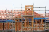
There are multiple problems with the Richards corridor in Davis. The most notable is that the number of vehicles moving through the main south entrance to downtown is too large for the road capacity. It is not just that the underpass has a single lane, but the surface streets in the south part of downtown Davis lack the ability to handle the volume of traffic at peak hours.
A second issue that is only partly related to the capacity issue is the problematic nature of the I-80 freeway interchange. During peak hours, traffic exiting westbound I-80 backs up onto the freeway off-ramp due in part to the traffic jam on Richards Blvd. But that situation is made worse by a mesh point that requires cars exiting the freeway to quickly merge – not only with motor vehicle traffic, but with pedestrians and bike paths.
During less congested hours, the mesh point is still equally problematic as cars are exiting the freeway and have to look over their shoulder to merge onto Richards Blvd while being wary of bikes and pedestrians and buses on the same route.
It is a problematic and dangerous situation and the city wants to change it. The city and CalTrans have created a tight-diamond design that they believe will alleviate the safety concerns – however, this will not change the core problem of throughput.
But funding those changes have been a problem for quite some time now. Originally the city was looking toward using RDA (Redevelopment Agency) money – but with the end of RDA, that has become a lost opportunity.
The city then looked toward the Nishi developers to fund part of the corridor plan, but that opportunity was lost when Nishi was voted down last June.
So now the city is pursuing a SACOG (Sacramento Area Council of Governments) grant as a way to fund the project, and it appears promising. As Public Works Director Bob Clarke explained to the Vanguard in an email, “SACOG staff have indicated our project would likely be more competitive in next years’ grant cycle if we show our commitment by investing local funds towards environmental clearance/final design and can show that it is ready to go to construction as soon as possible after grant funds are awarded.”
But yesterday’s article generated concern. The concern was that fixing the road, if it led to new development, was not optimal. As one reader put it, “I don’t view a solution which includes drastic increases in automobile traffic as a ‘fix.'”
I see the two issues as separate and distinct. On the one hand, the road right now is a problem. It is a safety risk and, even if there were zero new development, the city would need to fix this.
On the other hand, the determination about development along the corridor needs to be considered separately from the decisions to improve throughput.
Bob Clarke explained that the SACOG Regional/Local Grant Program “focuses on projects that provide regional benefits.”
The key criteria for submitting this grant program include the reduced congestion, improved flow of traffic, increase in multi-modal travel options including bike and pedestrian improvements, improved long-term economic benefits, improved traffic operations at Davis’ primary entrance from the interstate, improved access to Davis from I-80 at Richards, and improved safety which includes the separation of freeway traffic merges from Olive Drive intersection and a separate bike corridor.
He noted that“special consideration is also given to projects that have already funded initial phases with local resources.”
Specifically, he said, “SACOG doesn’t necessarily look to facilitate development, but does consider development the local agency is already considering, or has recently approved to ensure the transportation improvement works cohesively with other local decision-making that is compatible with the overall SACOG Blueprint.”
He said, “To that end, the proposed developments along the Richards and Olive corridors would be relevant in that the interchange project is compatible and coordinated with them.”
But, while they are relevant, they are not a requirement for the grant funding. In other words, Davis doesn’t have to develop any of the properties along the corridor in order to receive the funding.
The bottom line, as Bob Clarke put it, is that “the I-80/Richards interchange is the main public entrance to the City and its current design is outdated and no longer functions well to transition travelers from the freeway onto our local streets, nor is the Richards corridor ideally designed for the safe travel of peds, cyclists, transit riders, or motorists based on current complete streets principles. “
He said, “For these reasons, and if the City funds all the environmental and design work locally, it would be a very competitive project for grant funding in the next cycle. That does not guarantee it will be successful, just that we will have positioned the project as favorably as possible for funding.”
I understand that there are those who oppose development along the corridor – but should we not try to improve the safety of the freeway interchange because in the future it might make it easier to develop Nishi or Lincoln40?
That, once again, seems like backward thinking and the type of thinking that has led to paralysis in this community for too long.
—David M. Greenwald reporting


Wow – my comments yesterday apparently led to an entire article! I’m flattered, I guess. 🙂
I don’t think I’ll rehash all of the statements from yesterday. However, I will note again that no actual safety data was presented, in comparison with other regional interchanges.
Some are actively pushing for development along Olive (and on the Nishi site). This appears to be a primary motivation to “improve” the interchange, using taxpayer funds to benefit proposed private developments. If/when that occurs, there won’t be any “improvement” to traffic flow. (In fact, it will likely become worse.)
The final statement sentence (from the article, above) stood out for me:
In general, “paralysis” is often used as a derogatory term, by those pushing for development.
I debated putting Bob Clarke’s answer in a comment or a separate article, but there was enough to do it as a separate article.
BTW, In this case, paralysis means inability to fix a major corridor that’s a problem.
From article, above. Assuming that this is accurate:
Again, “fixing the problem” seems to be tied into “making the problem worse”.
Plainly stated that SACOG isn’t looking to facilitate development, they are more concerned with the transportation issues and the entry point to Davis.
David: Your own quotes show that SACOG is interested in facilitating “preferred” developments.
However, it’s not just SACOG. Some on the council seem to be interested in pushing for development in the areas discussed. Having an “improved” intersection (at taxpayer expense) will make it that much easier.
I read it as they “consider” it but don’t require it and that there are other and perhaps more important considerations.
David: I’ve repeatedly suggested in the past that you devote an entire article to SACOG, and the role that it plays in assigning “fair share” growth requirements, and the relationship it has with funding. There’s been a lot of disagreement, regarding how things work. (Generally, those pushing for development argue that it’s “not a factor”.) Seems like there’s a lack of honesty, regarding this.
But again, it’s ultimately some on the council (and others) who are pushing for development in the areas, discussed. To pretend otherwise, and that the proposed developments (including Lincoln 40, Nishi, and perhaps others) are not a factor (regarding the interchange improvements) is also dishonest.
And finally (regarding “honesty”), it’s dishonest to pretend that “improvements” will actually improve the situation, if/when developments are facilitated as a result.
You’re raising separate issues. The issue before us is whether SACOG’s grant is predicated on future development. The clear answer is no.
The next issue is whether the council is pushing for development along this corridor. The clear answer there is yes.
The central issue from my perspective is whether we need these upgrades to the road irrespective of other considerations. To me the clear answer there is yes.
My view would be if your goal is to stop development along this corridor, find another way to stop than to continue a highway interchange that is problematic.
David: We’re in a circle of repeating ourselves, at this point.
The two issues are intertwined. If/when the improvements facilitate development (that some clearly favor), then the situation won’t be “improved”.
I don’t view them as intertwined. There are other means to stop development than keeping a roadway that is non-functional.
David: You’re one of the individuals who is constantly pushing for more development, at times.
My concern here is safety. Keep an unsafe road to stop development is immoral in my opinion.
Actually, there has been discussion of making Richards safer since at least the last time widening the underpass was before the voters.
Don: Again, no comparative safety data was presented. And, those prior efforts failed, since residents realized that widening the underpass would just shift the problem into town.
“Improvements” might ultimately be safer, though. Difficult to get into serious accidents when there’s gridlock.
I will acknowledge that improvements for bicycle/pedestrian traffic would be desirable. However, I don’t support development just to obtain that, either.
Actually gridlock can lead to accidents as cars attempt to squeeze in and you miss bicyclists and pedestrians. But most of the day, that road is not gridlocked. How often do you drive through that corridor?
Background and Analysis
http://city-council.cityofdavis.org/Media/Default/Documents/PDF/CityCouncil/CouncilMeetings/Agendas/20141216/05C-Richards-Blvd-Interchange-Improvements.pdf
Sorry, David and Don. Not going to continue to fight both of you with circular arguments.
Sure – I’d like to see pedestrian/bicycle improvements.
But again, it’s a lie to pretend that most of the improvements sought for this corridor are not intertwined with proposed developments – which ultimately won’t improve the situation regarding auto traffic, at least.
I guess it’s a “coincidence” that Lincoln 40 is proposed, and some are hoping to resurrect Nishi (and perhaps other developments along Olive).
I wouldn’t characterize this as a fight – it’s a discussion of a difference of opinions. I believe that regardless of development along this corridor, the city would have to address the freeway interchange.
Improvements to Richards were under discussion long before Lincoln 40 or Nishi were proposed.
Hell yes… except, it came up with Nishi 1.0… which died a natural death… Nishi 2.0 died at the polls. The concepts (tight diamond) go back close to 15 years, if not longer.
As I recall, came up with the Olive Drive/Nishi Specific plan, and/or the UCD LRDP of the same/similar time frame.
Ron… 1972-73, Davis.
There were ~ 300-400 residences in South Davis… plan was brought forward to widen the OH on Richards… it was voted down, when the State was offering 83% of the financing, because “if we widen it, south Davis will start developing”… yeah, that ‘cork’ really worked well!
I was here then.
Will the planned improvements on their own at 80-Richards have regional benefits? I don’t see how: All it’s going to do is relieve motor vehicle congestion south of the two-lane tunnel temporarily, until more cars just filler up again. Increasing capacity here will only make Downtown motor vehicle traffic worse. No matter how you slice it or dice it, it’s still about shoving cars from a freeway through a tiny hole into a relatively small-scale street grid in a Downtown everyone wants to be more walkable.
Now to walking and cycling: The current situation is a horror show in terms of safety, but will this gem of a solution improve that? The current design is by the same company which did nothing to make East Covell and J safer and – if construction proceeds with the Mace and Cowell project – will perform a similar failure with this supposed solution aimed primarily at safe-ing routes to school. Their plan for this “tight diamond” which is in no way Beyond Platinum – thumbed up by the current Council, the former BTSSC and defended by staff experts – does not respect City policy, in which Class IV bike lanes – i.e. separated from both motor vehicles and pedestrians – are meant to be the default except in conditions which are not present at 80-Richards: Access to driveways and excessive additional cost. I don’t see how adding a safe, fully-segregated route for soft modes can add a significant proportional cost to the plan. The current planned path mixes pedestrians with cyclists, goes under a new westbound on-ramp to the 80 with a loop that has a steps-option for pedestrians with its bottom part at a tight right-angle turn at the bottom of the ramp for northbound cyclists, nearly completely stops momentum for cyclists going in both directions, has cyclists breathing deeply to accelerate up a ramp just yards away from the westbound traffic lanes on the 80 and terminates at Olive into not much more than the current sidewalk.
As we might imagine Caltrans has some restrictions on a design like this, but nothing’s clear about that in the plan except that Caltrans wants to use this for maintenance vehicles, which is possible as it’s not elevated except where it’s on the current structure. In other words – as far as I can tell – an elevated and direct path would be too expensive as it would need to be strong enough for heavy vehicles – whereas a path with full separation of pedestrians and cyclists – and both of them for motor vehicles – would only require access by a kind of relatively lightweight mini-truck used for cleaning ped-bike infrastructure. The planned path is intended to mix kids on bikes with Caltrans trucks!
Yes, the design does separate peds and cyclists from motor vehicles and reduces or removes the conflicts at the on- and off-ramps. But it’s otherwise a failure in planning, a violation – or at least an arguable cheat – of city policy. (Roughly parallel routes like the existing one via Research Park Drive to the Arboretum and plans/napkin sketches for connecting Pole Line to Olive Dr. or a new Pelz-type bridge that crosses 80 and goes directly to the Davis Depot are complementary; there should still be a direct route to 1st and E. A Pelz-type bridge that extended all the way to just south of 3rd St. on H St. with a ramp and elevator or stairs down to the Depot is compelling, however.)
Solutions:
– A project of Sacramento, Solano and Yolo Counties – a bus/HOV lane on 80 at least to Dixon and purchase of buses most appropriate for an express journey;
– Reduce Capitol Corridor ticket prices for the Davis-Sacramento route, with the deepest discounts for regular users and anyone under 16;
– For safe non-motorized mobility: A direct path – elevated as necessary – for pedestrians and cyclists which also separates them from each other all the way from the north side of Olive to the south side of Research Park Drive, with Class IV paths continuing further into South Davis;
– To reduce Downtown traffic from visitors and employees: Build the modified interchange with a provision for the construction of a future parking structure that would be directly accessed from both east and west 80 and that would also direct most traffic back onto the freeway (some who park here will still need to drive into the City). This structure would replace the one at 1st and F – the latter would be saved but re-purposed with e.g. restaurants – taxes $$$ – and so on on the rooftop and in aggregate both would facilitate Downtown walkability. There would be a free/included with parking and cheap to operate driver-less electric shuttle from the structure to Downtown, Davis Depot and the entrance to campus that operates 24/7;
– To reduce noise from 80 along its entire route through Davis, also provide for the future construction of an enclosure. This would be paid for by a toll – justified by its use as a anti-noise bridge across the City – and by generation of solar power: Panels along its south-facing side could generate about 15 to 20% of the current electricity needs of Davis (this is also about 40% of the amount generated at Monticello Dam.)
The bus/HOV lane is relatively straightforward and should be possible to plan with the May 2018 SACOG grant deadline in mind – I know that this is not an original idea by any means but are there plans to fund anything in the works?. The direct ped-bike path involves more engineering work in a sense but the key issue here is that it should be sub-contracted to another firm which has more experience in designing modern and safe infrastructure for pedestrians and cyclists. The planned old-school design for 80-Richards is a third strike for Mark Thomas; the approval or acquiescence of various entities in City government is a key part of this, but the company is simply incompetent in designing infrastructure for walking and cycling. The other concepts are indeed quite ambitious and certainly cannot come together for some years, but it’s vital that any current projects to improve 80-Richards facilitate further, deeper ones in the future.
I just don’t have the patience to figure all of the above out in detail — so I can’t imagine how anyone not into transportation could follow it at all. Brevity! Brevity! Brevity!
The point I agree on that I can squeeze from all this is the bicycle/ped path design leaves much to be desired and should be re-designed. It seems to many bike/ped designs are for meeting ADA or finding a cheap way to build a project, not for what works best for bike/ped circulation.
I have an easy solution to the problem of safety going over the overpass — DON’T. I have never once biked over that overpass except with police escort on the “Ride of Silence”. There’s a perfectly good tunnel under the freeway 1/4 mile south. I recommend using it.
Brevity shmevity! I agree to do a short version – thanks for the love! – but how does this compare to a typical EIR or other report which can spend many pages on explaining on how to get from LOS F to LOS E and back to LOS F again?
I would prefer a different plan entirely; stop allowing cars in downtown Davis. The downtown grid area is not large, approximately five blocks by seven blocks from A through G streets and 1st through 5th. This is all easily walkable. With the small street size and limited space available, we will always hit a bottleneck for cars going into south downtown. No increase in the size of Richards corridor will ever change that. So, why not increase parking on the south side of the tracks, and make the entire downtown area a no car zone? It would be great, downtown businesses would see a huge boost in foot traffic, it would be safer for pedestrians and cyclists and in the evenings, it would be much easier to police the bar scene.
In short order, there would be no businesses downtown (yes, an exaggeration). You don’t make a zone ‘walkable’ by getting rid of cars and delivery vehicles. All you will do is severely limit the economic viability of the zone, leading to vacancy and decay.
One of the things you can do is reduce the number of places where cars encroach upon the pedestrian areas, such as by reducing driveways crossing sidewalks. That is why the zoning downtown calls for new private parking to be hidden behind the buildings and accessed via the existing alleyways. Getting rid of the ‘parking islands’ (and their driveways) that currently exist downtown is another approach.
Alleys exist on few blocks of the City “core”… very few.
True, but where one exists there is absolutely no valid justification for creating another driveway across the sidewalk to service your private parking lot.
That isn’t going to happen. It took a decade to get bike lanes on 5th Street largely because downtown businesses at first fought the idea because they thought decreasing car lanes on 5th would reduce business.
Instead, I suggest proposing something more doable that would make downtown more ped-bike friendly and not (necessarily) raise the ire of downtown businesses into blocking any changes (such as “no cars in downtown”) would.
The suggestion is a pedestrian mall on E Street from 2nd to 4th, and a bikeway on 3rd Street to connect L Street to A Street (campus, a through route across town), bike-ped only from C Street to F Street. On both, allow cars to progress onto the ped-bike ways at 5-mph with a store-issued permit for pickups. 3rd and E Streets would be the bike-ped center mall area, with much friendly architecture and art as a public space.
This is do-able.
I really like this proposal! Thank, you Alan.
Why would we do it? Is there a serious problem this is supposed to fix?
I agree, it just takes away that many more parking spaces and concentrates traffic on less streets.
I have an idea, let’s stop allowing bicycles downtown and make it easier for cars to get around.
Keith: Your “O” – normally a quite powerful pagan symbol about the cycle of life – is meant to be ironic, yes?
Todd, the “O” in Keith O is actually a “zero” as in zero patience for bicycle advocates who for their own selfish benefit are always trying to ban and restrict cars.
Cars.
The Kieth ZerO “Incomplete Streets” policy.
It would be our “Santa Monica 4th Street Pedestrian Mall”.
Sort of like how Putah Creek is our Venice Canal system.
Alan, you do know that no bikes are allowed in Venice? 🙂
No cars allowed either. #zing!#
This is a good plan, to start because it doesn’t do anything wrong. If people like it can be expanded.
I would, however, shift the ped zone to E between 1st and 3rd so that the bike priority street is a northern border to the slower zone, and light rail is its southern border. I would also expand it into all of the Second St. Plazarking lot.
Also my concept above assumes that some local and Downtown-desination motorized traffic will go through via 1st and the past the Depot and along 1st to campus and north on B. Some of it, however, can be diverted one exit west or to Russell via 113.
WHAT light rail?
2nd to 4th to allow distribution of traffic up E to 2nd in both directions. 1st alone cannot handle the auto traffic.
Great plan, it will work wonders freeing up our downtown grid with less traffic and auto congestion. Also with less people visiting and shopping downtown and all the resultant closures of businesses and storefronts it will also be much easier for the remaining bikers and pedestrians to navigate the area.
“Soon the Streets will be be OURS”, said Mister Miller, petting his long haired white cat.
An E Street pedestrian mall 2nd-4th was first formally proposed by Davis Downtown 6 or 7 years ago.
And in 1961. And a variety of other proposals have come and gone. In the absence of willing landowners and interested retailers, there’s little point in these discussions.
http://cityofdavis.org/about-davis/history-symbols/davis-history-books/growing-pains-chapter-9
Yes, a truly-dedicated express bus lane on the 80 that includes separate egress is very complicated. Nevertheless an HOV lane and express point-to-point buses could help a lot.
There is also a plan going forward at SACOG for a short-haul railway service between Sacramento and Davis. There are systems in Europe that use tram-trains which use both on-street light rail infrastructure and heavy rail infrastructure. Imagine a solution like this between West Sacramento that would access the developing area along the river, in East Davis would stop near Mace, and in downtown would proceed from the Depot down 1st St to campus. (One service would terminate in Sacramento and one would terminate in West Sac.)
This is NOT going to happen. A plan does not a funded project make.
That will fly with Union Pacific when they use camels as locomotives.
STRONGLY (yes, yelling!) agreeing with Alan on both counts…
Pipe dreams (short haul rail between DAV and SAC) and you can guess what is burning in those pipes… and, the SACOG plan is not a plan, it is a concept… a concept that is worthy of being pursued, with the knowledge it won’t be a reality in the next 30+ years… a longer planning horizon is somewhat reasonable…
Because why, Howard P(atience)? Everything starts with a concept and my – yes, guess – is that a short haul railway could work here as there’d space for slots in between Capitol Corridor and freight services, i.e. it would simply be less in the way than the same kind of thing in relation to CC services in-between Oakland-Coliseum and Richmond stations, as there is less freight traffic on this short section. For the same reason it’d be less in the way there’d be fewer chances for disruptions to the passenger service schedule. With a new track accessing a station at Mace, there’d also be a chance for trains to pass, in a way the train going off the track to the street would serve the same purpose.
Tram-trains are ideally suited what I mentioned but I am not sure about the regulatory picture, mainly if PTC (positive train control, just Google it….) will eventually enable heavier and lighter trains to share the same track in any kind of possible proximity.
Pushing for it can make it go faster, right? You seem to always mention a 30 year time-frame for things, right? Perhaps that’s why projects take decades to happen and not the other way around.
Because UPRR owns the right of way and they don’t want increased passenger service interfering with their heavily used main line. Further, the limitations of the trestle between Sac and Davis and the cost of any necessary upgrades make service expansion nearly impossible on that section. While I share your opinion on the desirability of such a local service, I accept the reality of what Howard and Alan M. have been saying. It won’t happen in our lifetimes. Repeatedly putting it forward as a solution to current term problems is disrespectful.
Alan M. and Mark W. agree.
The Moon has collided with the Sun.
I concur 100%.
R — how would you improve safety on Olive / Richards without changes that could “encourage development”?
I would characterize it as a two-day c****e j**k.
Yes, it was, Alan, but you will notice how Todd’s impossibly complicated and intricate plan poured cold water on it.
Since I “stepped out” of the conversation for awhile, it’s become infinitely more entertaining.
But, I am glad to see ideas presented (even intricate ones, which I’m not fully following). I think I’d need a map and presentation for some of those.
How about this, regarding the railroad right-of-way (which is mentioned here, and comes up periodically):
Eminent domain?
Hey – railroads were “given” quite a bit by the government in the first place, back in the day. That’s how the Big 4 became so wealthy and influential, to begin with. (That, and almost slave-labor conditions, for workers.)
Just throwin’ it out there to think about, and stir things up. (Not a serious suggestion, at this point.)
Railroad are one of the few entities that have the power of eminent domain. It doesn’t work backwards.
Alan: Wow – didn’t know that. I’ll probably look into how that occurred, out of curiosity. (Hey – I just learned something about the spelling of that word, as well! No 2nd “u”, in there.)
Again, it wasn’t a serious suggestion (especially at this point). Just presenting my more “radical” side.
I know, I’ve been watching “Hell on Wheels”.
Hey – just thought of something: Amtrak is a “railroad” (sort of). 🙂
True in some states, not in others… not sure where CA falls… it is a power granted by States, not the US.
Most railroad rights of way were given (“granted”) to the RR’s by the Federal Government, across federal lands (‘public lands’)… and it generally was not R/W, it was fee title (fee simple)… along with alternating sections of land on either side… and I mean ‘sections’ in the surveying sense… 1 mile wide, one mile deep. [ever notice why railyards are almost always only on one side of the main line?… think…]
But a ‘do-ever’ is not a happening thing…
“Todd’s impossibly complicated and intricate plan” WOULD keep the hotels and restaurants packed for months and months, and that would just be the people coming for the first time to check out the town that created an amazing downtown area, quieted the highway, created single mode journeys without cars from housing in West Sac to the UC Davis campus, implemented cheap parking in the footprint of a re-developed interchange with autonomous transfer to Downtown at no extra cost, generated solar power for 1/5 of residential needs on the roof a freeway sheath for which the US Supreme Court ruled could also be paid for with a toll and so on and so on and so on. You can grow ideas in the garden of your mind. It’s good to be curious about many things.