

On Tuesday will be the fourth public hearing for the city’s districting process. They will receive further input on proposed district maps, select the final district map and introduce an ordinance to transition to district elections.
The council could have further limited the scope when Mayor Brett Lee asked each council member for their preference of five or seven districts – but while Will Arnold and Dan Carson prefer five, Gloria Partida and Lucas Frerichs prefer seven, and Mayor Lee, for reasons unspecified, declined to break the tie.
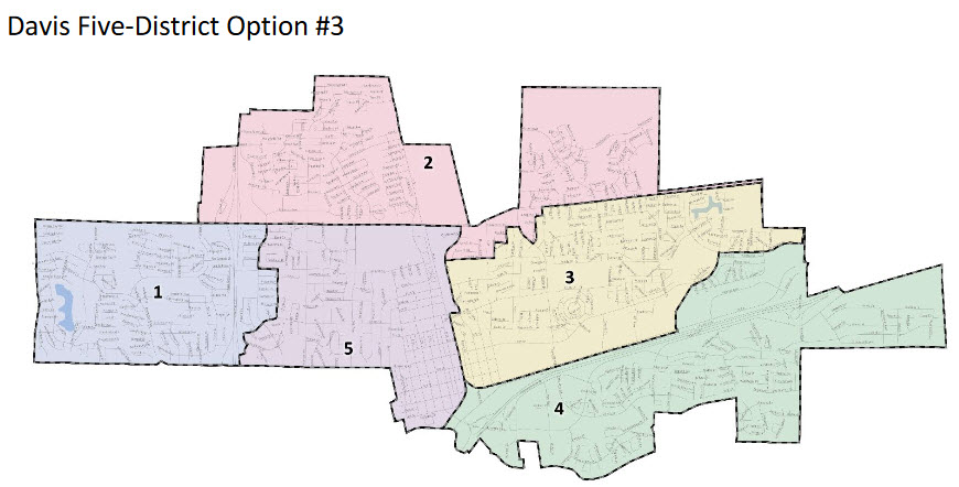
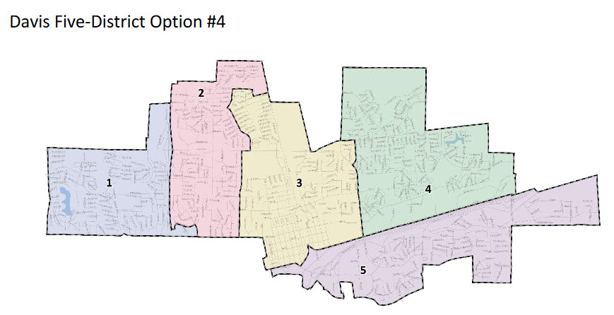
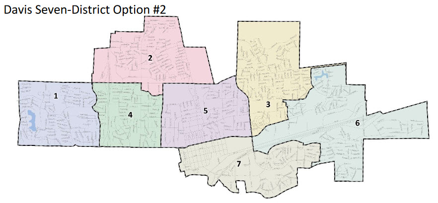
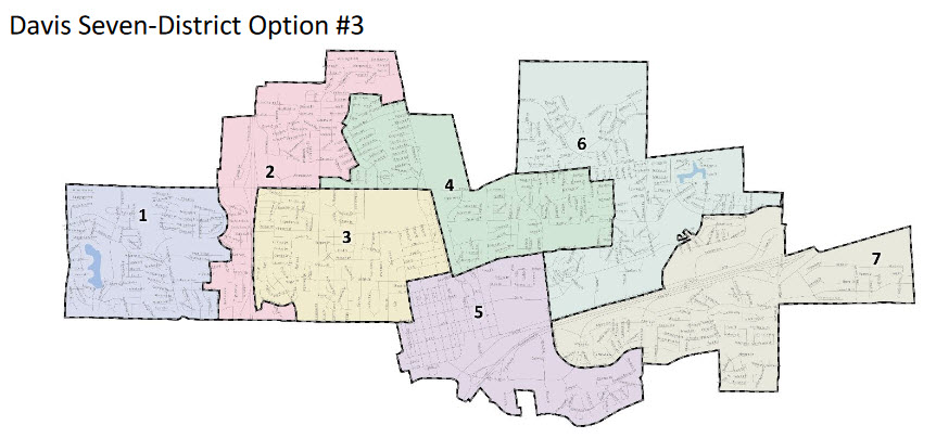
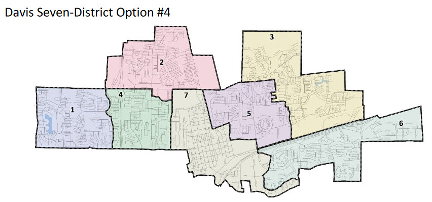
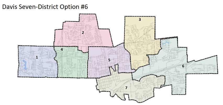
As a result there are ten additional district maps presented this week – four that are five districts and six that are seven districts.
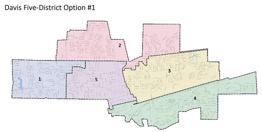
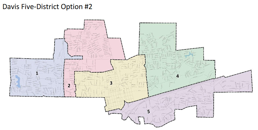


Councilmember Arnold indicated that he prefers the 5-2 map for the district – the second five-member district map. He said that he was not initially in favor of moving to seven-member districts, but sees some advantages there.
Mayor Pro Tem Gloria Partida said, “I am leaning towards a seven district map,” but cautioned that having seven members “is going to make it more difficult” to run meetings.
Councilmember Lucas Frerichs is probably the strongest supporter of the seven-member districts.
“I still remain interested or supportive of the potential of seven districts,” he said. “Lowering the barriers to entry, smaller geographic areas, lower population, so therefore it’s conceivably less expensive to run for election as a opposed to a citywide election.”
He does have some concerns about tribalism that might form, but thinks “some of that exists today without districts.
“We have the ability to do what’s best for the city,” he said.
On the other hand, Dan Carson remains the most outspoken for five.
“I’m going to make my pitch for five districts,” he said.
He noted that he believes going to seven will bring about $100,000 in additional costs.
“These meetings run long,” he warned. “Having seven of us will run longer, folks.
“I love working with my colleagues,” he said. “As the issues get tougher, the harder we work to compromise.”
He said, “I am nervous that going to seven changes that dynamic.
“Maybe it doesn’t,” he said. “But I worry.”
He is concerned that there is a natural tendency they will start to divide up into factions.
“I don’t want that,” he said.
Brett Lee, while not committing to five or seven, did note, “Humankind can probably figure out how to run a meeting with seven people.”
—David M. Greenwald reporting


VG… any idea when the staff report showing breakdowns of demographic/rationale(s) for boundaries will be available?
https://www.cityofdavis.org/city-hall/city-clerk/elections/district-elections/maps
Click on the pdf versions and it has the demographic breakdowns
thx…
Yesterday I formally submitted the following to the City:
I am very pleased with the open-mindedness and quality of of Paul Mitchell’s work with Staff on the Districting process.
The parade of students/renters, who on October 8th supported either 7 District Option 2 or the Renter/Student map submitted by Don Gibson (see http://documents.cityofdavis.org/Media/CityManagersOffice/Documents/PDF/CMO/City-Clerk/District-Elections/Maps/Community-Map-Submittal-2019-10-01-Gibson.pdf), was a clear message that the opportunity to improve enfranchisement for renters has clearly been heard.
The one area that I believe was not addressed in either 7 District Option 2 or the Gibson map was the under-representation of the portion of the Davis population that is socio-economically challenged. Unlike the racial/ethnic population in Davis, which is dispersed through the community without any significant geographic areas of concentration, I believe there are three good ways to see the coherent geographic area of concentration of the Davis residents who are socio-economically disadvantaged.
The first of those three ways is through a mapping of the location (at the Census Block level, so that the privacy of the individuals is not violated, of the students who qualify for subsidized lunched in DJUSD. The school district has year-by-year GIS information that they could share with Paul Mitchell and City Staff.
The second of those three ways is through a mapping of the geographic dispersion of residences where the household income falls into the socio-economically challenged cohorts.
The third of those three ways is through a mapping of the Davis households that have the lowest incidence of four-year undergraduate College degrees. It has been reported that 74% of the adults in Davis have a four-year college degree. If that 74% figure is correct, the 26% of the adults who do not have such a degree face significantly greater socio-economic challenges than thos adults who have such a degree.
Absent concrete data to confirm my suspicions, I share (formally submit) herein a 7-district map that retains the renter/student empowerment features of Don Gibson’s map, as well as creating a district that includes the portion of the City that I believe has the highest concentration of socio-economically challenged residents. The coherent, contiguous geographic area of that district would start at the southern border of Nugget Fields on Pole Line and follow Pole Line south until reaching Montgomery Elementary School. According to the maps provided by Paul Mitchell, such a “Subsidized School Lunches” district would have as population of 9,430 residents which is only 0.59% away from the 9,375 “City-wide average” in a 7 District scenario.
Bottom-line, the whole point of the CVRA was/is to address the disenfranchisement/under-representation of the vulnerable communities of interest. I would argue that the socio-economically deprived residents of Davis fit that description to a tee.
Thank you for your consideration of this formal submission to the districting process.
Sincerely,
Matt Williams
I so disagree with the 7-district approach, and,
No, it doesn’t… problems with definition of SED, and plain words, and stated intent (in the bill) of CVRA… an extrapolation.
But we can agree to disagree… I still favor a non-gerrymandered map, comprised of 5 districts… 5-1, and 5-4 fit that bill (5-2 is marginal)… the ONLY 7-district proposal that is not obviously gerrymandered (to what real purpose, is unclear) is 7-2, and that is of question.
Sure sounds like some are looking for a “quota system”, and those haven’t worked out real well… for people and in case law (ex. Bakke… who was a jerk, who had a good case)
Bill, I believe that a lot of what you visually see as gerrymandering is probably only compliance with the equal population size requirements of the law, combined with the demographer’s strong suggestion that individual census blocks. Those census block boundaries (as provided by the City in their laminated graphics) do not follow the kind of straight lines that I suspect you associate with an absence of gerrymandering.
My personal opinion is that the “perspective” of 5 districts is “looking backward,” honoring the past history of Davis, while the “perspective” of 7 districts is “looking forward” recognizing both the evolution of Davis over the years from a high proportion of owner-occupied residences to a minority of owner-occupied residences, and that minority is shrinking further every year. 7 districts acknowledges that change. 5 districts tries (in my opinion) to sweep that change under the rug.
JMO
Past history of Davis has been one district… 5 is in itself a huge step forward.
7 is a step too far, too soon.
JMO
For the record, historic neighborhoods are intact in all the new maps. Thanks to Council & demographer.
Mostly… not in all versions… but, mostly…
As to your other question, as to current CC residences (hence, new districts)…
Rest assured that the most fervent CC member on 7 districts is concerned about how 5 are drawn…
On the new ones, where does it not?
You are implying something . . .
Your definition of OED going to L, and north of Fifth…
7-6 is ‘on the bubble… 7-2 has n’ly boundary at Fifth… 5-1 excludes some west of L, n/Fifth…
Like I said, “mostly”…
Nope. 7-6 has a strange boundary due to the precincts, but technically it does enclose Old East. I don’t like it because it cuts the neighborhood to the north between 6th and 8th (called Huntwood or something like that?) that is not official but is a neighborhood, and was part of the original Old East Davis group that pre-dated the official OEDNA (late 80’s is when).
The other two are not new maps. The included the old maps along with the new ones. Most of the new ones are refined versions of the old ones, with CC input.
Alan… comments noted… you defined OED, not me… not my issue… truly care not…
Just trying to affirm… my bad… I apologize…
I defined? No. This is the ACTUAL City codified definition — but it doesn’t go to Fifth, it goes to “Sixth” (Yale Street and all addresses in the 500’s on lettered streets). Type it into Google Maps, one of the few entities that got it perfect (sans the inclusion of the Korean Church, which technically isn’t).
You should care because I care. Because I am an important dude. So say I!
Curious why the VG had maps of where the school board members lived and districts, but not where the council members live and their districts. The whole thing is oogie, and I’d rather not give such information although it’s probably public record. But curious why — or is that tomorrow? If so, vague area is good. Would be good to at least keep a public eye on the choice made not being about re-election.
Because the School District provided those on the maps while the City didn’t
Fascinating. Thanks.
Of course not… some apparent COI’s might become apparent…
Is it too much to ask for someone to figure this out? I’m not asking to Dox the Councilmemebers — I’d just like to see the process transparent so it’s done only on the merits.
B Street
Parkside Dr. South Campus Way.Rondo Pl
Flamenco Pl
Cumberland Pl
Note correction edited in.
No Alan… it’s just I don’t have full documentation… City Clerk does… as likely whatever they are calling Community Development these days… they have to track addresses to avoid statutory COI’s on items considered by the CC…
Here, it’s weird… technically, one could argue that each current CC has a technical COI … but not, IMO a ‘real’ one… legally…
The City could include the information without posting the specific addresses simply by providing a list with each map stating in which proposed districts current CC members lives. For example…”One current CC member resides in each of districts 2,4,7 and two members reside in district 6 in this proposed map.”
Yeah, that’s a good solution. Better than the “X marks the spot” of the school district maps. Then it could be shown graphically with little trouble by dropping an X center-district.
These are all specific enough to be 3 blocks or less, except #1, which is the only one I know, and is between 7th and 8th. Thus, this can now be mapped by district. So, does the VG have a graphics dept? As this decision is Tuesday, this should come out now (-ish).
This is a very strange way for the City to conduct the process. Are we as citizens just supposed to comment on district shapes (and the summary accompanying demographic information) without anything else to go on? There doesn’t seem to be any kind of accompanying narrative as to why the boundaries were drawn the way they were for each, and what types of goals a particular map has. This is just like a “black box” type thing: “we have reasons for drawing these different districts in different ways, but we aren’t going to tell you what they are”.
There should be a narrative attached to each of the maps, so citizens would clearly know the rationale/goals behind each option and why they were drawn the way they were.
BTW… slightly off-topic… DJUSD covers more area, more people and voters than the City… why is it OK they aren’t going to 7?…
The “phasing” might be convenient, but could be troublesome… for some… depending how the boundaries are drawn…
Resolvable by making all seats open in 2020… until all seats are by district, not “at large”, some ‘districts’ may have double representation… if one believes that CC members need to “represent” their current/proposed districts…
Likely ‘fact’ is some of the ‘at large’ CC will act, seeing their future districts… and act accordingly… and, if there is an overlap, will those who are elected by district in 2020 have an advantage over incumbents who wind up in the same district?
I have no answer… raising the question(s)… would be more fair (who cares about that?) to have 5 positions (preference) or 7 folk (at least two ‘newbies’) stand for election Nov 2020… cleaner… otherwise, we have a mixed bag for 2 years…
And, there is the extension of terms of ~ six months, for the three who are up for re-election, whose terms would otherwise expire June 30, 2020, as the district vote thing could not happen until Nov 2020… is that ‘just’?