The city has posted the Subsequent EIR (SEIR) on its site, and has begun the 45-day public review period that began on March 13 and will end on April 27, allowing the public to comment on it.
The proposal could go to the Planning Commission and City Council by May to be placed on the ballot for a possible November vote.
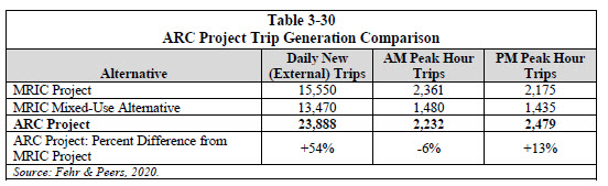
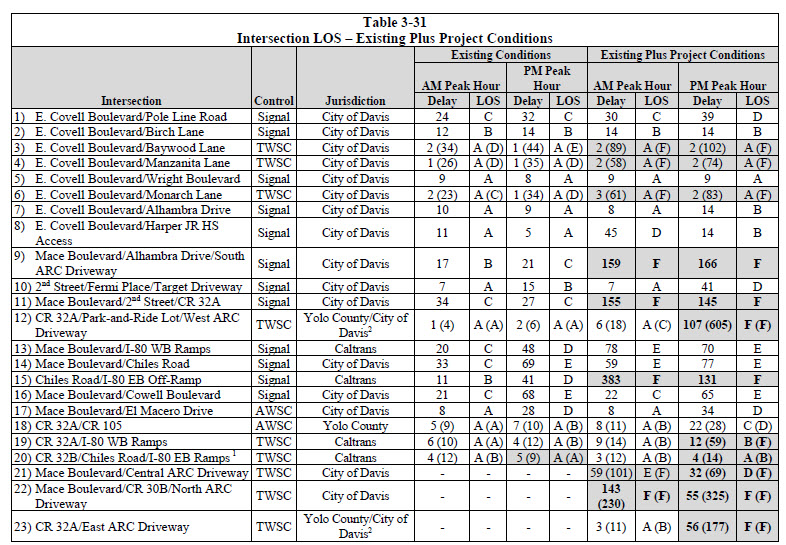
Between the worsening conditions on Mace and the expected added traffic now projected at nearly 24 thousand external vehicle trips per day, an area of large concern is the impact on traffic, especially on the Mace overpass.
The SEIR and traffic analysis concludes that, with fairly extensive enhancements, impacts from the project can be reduced.
The SEIR notes that while the MRIC Final EIR “utilized baseline traffic count data collected in October 2014,” traffic counts that were conducted in May and October 2019 “indicate that peak hour traffic volumes on roadways within the vicinity of the project site have increased substantially since that time, particularly during the PM peak hour.”
Therefore, “the baseline traffic conditions that the project would interact with on study area roadways reflect higher levels of traffic volumes and delay than those studied in the Certified Final EIR.”
They also note some changes to the project itself: “Although land uses have not technically changed, several subtle modifications to the project description for the mixed-use alternative analyzed in the MRIC EIR have occurred. This includes differing assumptions regarding the extent to which the project’s housing and retail component complements its other uses, as well as modifications to  project access and off-site transportation improvements.”
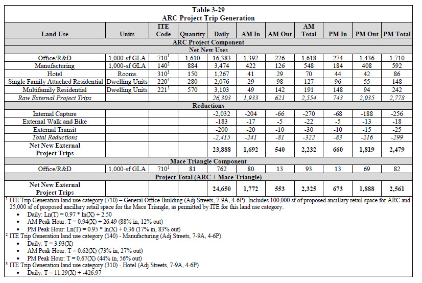
According to Fehr & Peers, “the ARC Project would generate 23,888 new daily (external) vehicle trips, with 2,232 trips occurring during the AM peak hour and 2,479 trips occurring during the PM peak hour.”
For the ARC Project, the EIR notes, “the worst-case intersections were determined to be I-80 WB Ramps/Mace Boulevard during the PM peak hour and I-80 EB Off-Ramp/Chiles Road during the AM peak hour under Cumulative Plus Project Conditions, due to worst LOS, highest delays, and highest volumes.”
They further find that the impact of additional traffic at I-80 and CR 32A interchange would “exacerbate these LOS F conditions and exceed applicable Caltrans LOS thresholds.”
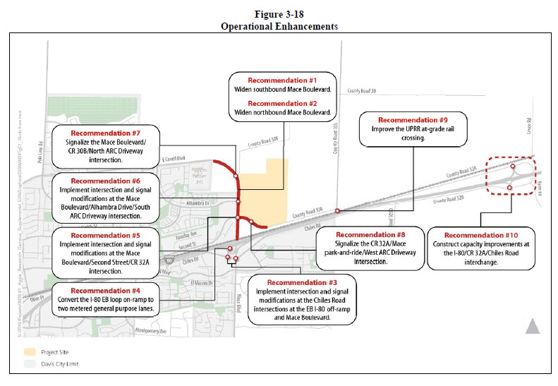
The question is what can be done and they present a number of mitigation measures.
- Add a second eastbound/southbound lane from Harper Junior High School to Alhambra Drive. Add a third southbound lane from 2nd Street to connect with the dedicated right-turn lane onto the I-80 WB on-ramps
- Extend the third northbound lane from the I-80 WB offramps to connect with a new northbound “trap” right-turn lane at the Mace Boulevard/2nd/CR 32A intersection. Add a second northbound/westbound lane from 2nd Street to the Harper Junior High School signalized intersection.
- Coordinate the intersections at Mace and Chiles and Chiles and I-80 EB Off-Ramp Intersections. “This pair of tightly spaced intersections (situated 450 feet apart) requires signal coordination/timing adjustments and a lane reassignment on the eastbound Chiles Road approach to Mace Boulevard due to the heavy project-related off-ramp volume during the AM peak hour.”
- Changes to Eastbound Loop On-Ramp: “This on-ramp consists of a single entry lane from southbound Mace Boulevard, which widens to a metered general purpose lane and an unmetered HOV bypass lane. During the PM peak hour, the addition of project trips would cause queue spillback from the ramp meter onto the overpass, thereby causing queue spillback to extend further upstream. The recommended modification from an unmetered HOV bypass lane to a metered general purpose lane was found to provide more ramp metering storage, and reduced effects on the surface street.”
- At Mace and 2nd: “Modify the northbound approach to add a “trap” right-turn lane. Modify the westbound approach to two left-turn lanes and a shared through-right lane. Modify westbound CR 32A between this intersection and the adjacent CR 32A/Mace Park-and-Ride/West ARC Driveway intersection to have two through lanes.”
- At Mace and Alhambra: “Modify the westbound approach to two left-turn lanes and a shared through-right lane. Provide a southbound left-turn lane, two through lanes, and a right-turn lane.”
- Install a traffic signal at Mace and CR 30B
- Install a traffic signal at CR 32A and Mace Park and Ride
- Widen CR 32A to meet Yolo County standards for a two-lane arterial
The impacts of the project are thus quite significant.
The SEIR finds: “When the percent demand served drops well below 100 percent, the demand for travel cannot be served within a single hour due to either upstream or downstream bottlenecks. This can lead to ‘peak hour spreading’, which is generally defined as more than one hour of congested, stop-and-go conditions.”
In effect, the project would cause the system-wide percent demand served to decrease from nearly 100 percent under existing conditions to just 82 percent for AM peak hour and 85 percent for PM peak hour.
However, with the recommended changes, “these percentages increase to 99 percent during the AM peak hour and 97 percent during the PM peak hour, a substantial improvement.”
Most importantly, with such enhancements, “vehicle queues would no longer spill back onto the I-80 mainline with implementation of these enhancements.”
Overall, they concluded, “Background traffic growth will require improvements within this portion of the study area regardless of whether the project is developed.”
Second, “The ARC Project would further worsen operations in this area, though the operational enhancements would provide some benefit. For instance, in the PM peak hour, the percent demand served under Cumulative Plus Project conditions would increase from 65 percent to 83 percent with the enhancements. However, the operational enhancements are not sufficient, in and of themselves, to improve conditions to LOS E or better.”
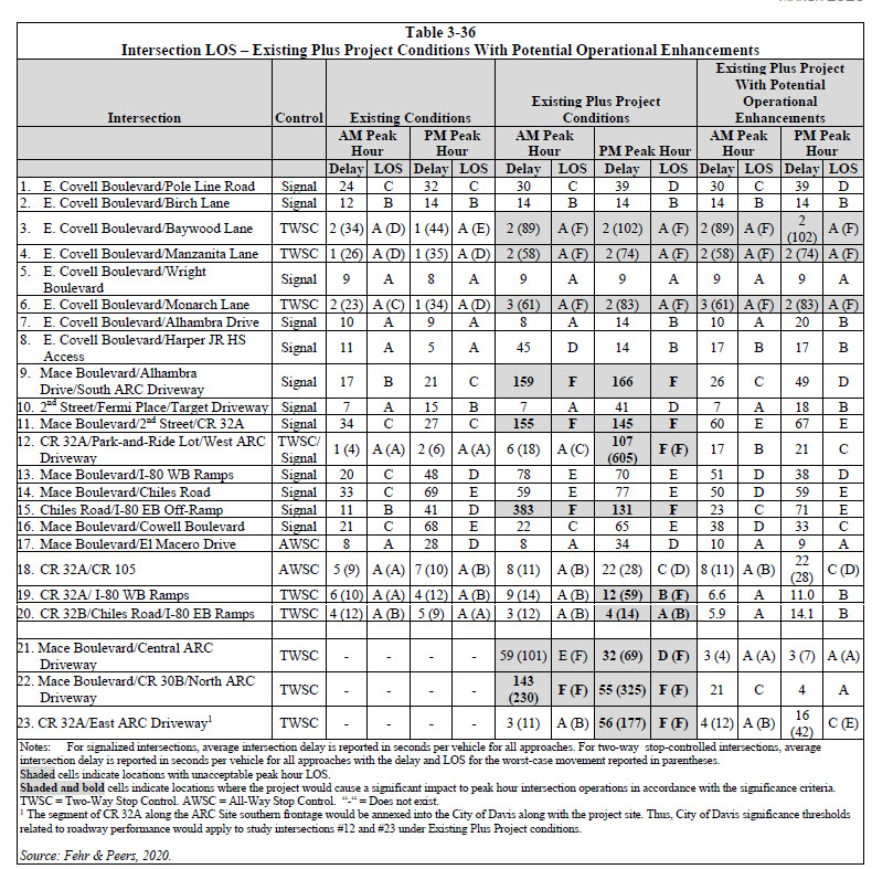
However, they find that the enhancements identified “would serve to improve operations at the impacted facilities under Cumulative Plus Project conditions.”
But they warn: “However, it is important to note that Mitigation Measure 3-70(a) requires the applicant to work in good faith with Caltrans, Yolo County, and the City to identify feasible physical improvements to the roadway network for purposes of improving operational performance.”
These would also require I-80 corridor improvements and improvements of TDM (Transportation demand management) strategies.
—David M. Greenwald reporting


I am reading through Appendix F line by line, and thus far have not run into what I believe is the most important part of the data … a flow vector chart and diagram that shows how many additional trips will be generated in the key periods, and what route those trips will follow. For example,
Afternoon Trips
(1)Leaving ARC by the ____ exit and proceeding south on Mace to the I-80 Westbound slip on-ramp
(2) Leaving ARC by the ____ exit and proceeding south on Mace to the I-80 Eastbound slip on-ramp
(3) Leaving ARC by the ____ exit and proceeding south on Mace to westbound 2nd Street
(4) Leaving ARC by the ____ exit and proceeding south on Mace thru the Chiles Road intersection to points south
(5) Leaving ARC by the ____ exit and proceeding south on Mace to westbound Chiles
(6) Leaving ARC by the ____ exit and proceeding south on Mace to eastbound Chiles
(7) Leaving ARC by the ____ exit and proceeding west on Alhambra
(8) Leaving ARC by the ____ exit and proceeding north on Mace to westbound Covell
(9) Leaving ARC by the ____ exit and proceeding east on County Road 30A
(10) Leaving ARC by the ____ exit and proceeding north on County Road 105
I believe those are the ten options for the flow vector chart, and the values should add up to the total number of added trips.
You left out internal, and ostensibly, non-MV trips… but essentially, your point is valid… to a point.
Trips are one thing… traffic another… somewhat joined at the hip, but not a 1:1 correlation
Where is the glider? Where are the windmills?
Some (hopefully objective) thoughts on the presented mitigation measures.
(1a) Add a second eastbound/southbound lane from Harper Junior High School to Alhambra Drive.
How much of an effect this will have depends on the mix of vehicles approaching the Alhambra intersection. Understanding how many of the vehicles will be turning left into ARC and how many will be continuing thru the Alhambra intersection in each hourly period will be very helpful. This is an improvement that should happen regardless of whether ARC is approved or not.
(1b) Add a third southbound lane from 2nd Street to connect with the dedicated right-turn lane onto the I-80 WB on-ramps.
Here too, understanding how the volumes in each of the three lanes will be apportioned is key. Having a I-80 westbound on-ramp only lane could “bleed off” traffic from the current southbound right lane, which is almost exclusively dedicated to vehicles queued up to enter the I-80 eastbound loop on ramp. Having the third lane will not affect the amount of delay the vehicles in that lane experience. Their travel time is governed by the meter at the end of the eastbound I-80 on-ramp. Right now CalTrans has no meter on the I-80 westbound on-ramp. An unknown is whether the added volume could cause CalTrans to change that.
(2a) Extend the third northbound lane from the I-80 WB off-ramps to connect with a new northbound “trap” right-turn lane at the Mace Boulevard/2nd/CR 32A intersection.
This suggestion should help in the AM peak hour.
(2b) Add a second northbound/westbound lane from 2nd Street to the Harper Junior High School signalized intersection.
This suggestion should help in the PM peak hour.
(3) Coordinate the intersections at Mace and Chiles and Chiles and I-80 EB Off-Ramp Intersections. “This pair of tightly spaced intersections (situated 450 feet apart) requires signal coordination/timing adjustments and a lane reassignment on the eastbound Chiles Road approach to Mace Boulevard due to the heavy project-related off-ramp volume during the AM peak hour.”
One would hope that the City has already coordinated/timed these two lights, so it is hard to imagine how much of an impact further coordination/timing will have. In addition, the traffic signal at the end of the eastbound I-80 off-ramp is controlled by an activity trip switch so that the signal turns green almost immediately after a vehicle enters the off-ramp. That will present a challenge to coordination/timing efforts.
(4) Changes to Eastbound Loop On-Ramp: “This on-ramp consists of a single entry lane from southbound Mace Boulevard, which widens to a metered general purpose lane and an unmetered HOV bypass lane. During the PM peak hour, the addition of project trips would cause queue spillback from the ramp meter onto the overpass, thereby causing queue spillback to extend further upstream. The recommended modification from an unmetered HOV bypass lane to a metered general purpose lane was found to provide more ramp metering storage, and reduced effects on the surface street.”
I agree with everything said in this recommendation, but the final statement is vague and general. How much additional ramp metering storage and how much of a reduced effect. We already know that the current volumes push the queue back onto the Mace Curve, and often even to Harper Junior High. When nthe added ARC volume and the reduced effects of eliminating the HOV lane are netted out, what will be the impact on the current conditions?
(5) At Mace and 2nd: “Modify the northbound approach to add a “trap” right-turn lane. Modify the westbound approach to two left-turn lanes and a shared through-right lane. Modify westbound CR 32A between this intersection and the adjacent CR 32A/Mace Park-and-Ride/West ARC Driveway intersection to have two through lanes.”
Isn’t this suggestion the same as (2a) above?
(6) At Mace and Alhambra: “Modify the westbound approach to two left-turn lanes and a shared through-right lane. Provide a southbound left-turn lane, two through lanes, and a right-turn lane.”
There currently isn’t a westbound approach at the Mace and Alhambra intersection.
Install a traffic signal at Mace and CR 30B
Definitely necessary, but it won’t affect travel times positively for the existing travelers on Mace. It will help ARC vehicles get onto Mace.
Install a traffic signal at CR 32A and Mace Park and Ride
Definitely necessary, but it won’t affect travel times positively for the existing travelers on CR32A. It will help ARC vehicles get onto CR32A.
Widen CR 32A to meet Yolo County standards for a two-lane arterial
Definitely a nice-to-have improvement, but I don’t see how it will improve existing travel time
This article is misleading in that what David is calling “mitigation measures” are what Fehr and Peers actually calls “potential operational enhancements“. They are actually not mitigation measures and appear to be totally distinct from the list of those officially identified mitigations in the SEIR. There appears to be no tie-in between actual recommend mitigation measures for the project and these “potential operational enhancements”.
It appears that Fehr and Peers identified this list of “potential operational enhancements” in order to present a future scenario that looks more rosy. The “potential operational enhancements” consist of a wishlist of massive roadway construction projects with an unknown price tag and feasibility. And even the study recognizes that increasing capacity in this way would have deleterious effects on local traffic and bicycle-pedestrian safety . From p. 26:
“Note that while the improvements listed above provide benefits to peak hour roadway operations for vehicles, they could diminish the bicycle and pedestrian environment by increasing crossing distances and bicycle and pedestrian exposure times at intersections. Moreover, the additional roadway capacity resulting from these improvements could induce additional vehicle miles traveled (VMT) on study area roadways. Existing evidence indicates that Covell Boulevard, Mace Boulevard, and connecting roadways such as Second Street and Chiles Road are utilized as regional cut-through routes when I-80 experiences significant speed reductions and delays during p.m. peak periods. Therefore, improving operations and reducing delays along these local roadways could increase the attractiveness of these routes as alternatives to I-80 and induce additional regional cut-through activity on local roadways. Parallel local routes require longer trip distances than remaining on I-80, therefore, regional travel demand use of local routes would yield more VMT than use of I-80.“
As noted throughout the EIR, the ARC proposal now includes 5,858 parking spaces.
http://documents.cityofdavis.org/Media/CityCouncil/Documents/PDF/CDD/Aggie%20Research%20Campus/20200427%20SEIR%20NOA/Aggie%20Research%20Campus%20Draft%20Subsequent%20EIR.pdf
Thanks for the update Ron, I’ve always thought the number was 4340.
The parking space numbers seem to multiplying like Coronavirus.
The proposal is not for 5858 parking spaces. Maybe that’s what they analyzed, but that’s not the proposal.
Thanks David, honest question, why would they analyze 5858 if the actual were 4340?
Is 5858 what they feel is actually needed for the project of that size?
Appears this is the answer: “ The Mixed-Use Alternative included 6,032 on-site parking spaces, whereas the ARC Project includes 5,858 parking spaces, a reduction of 174 parking spaces. While the applicant’s original submittal materials for the ARC Project identified a parking total of 4,340 on-site spaces, during the environmental review process, the number of on-site parking spaces was increased, upon recommendation of the traffic consultant, to be consistent with the parking demand estimate calculated for the project using the Institute of Transportation Engineers Parking Generation Manual”
I’m following up as to whether the proposal is now 5858 or 4340.
I’m assuming that this reduction (of approximately 27 acres of green space) will now be covered in parking lots to accommodate the 5,858 parking spaces. And that the remaining green space will be privately-owned.
From the EIR: