There will be no decision made on Cannery on Tuesday. According to the staff report, “The purpose of the October 22 workshop is to introduce the project and applications to the City Council and the public. Although many of the materials will be available in advance of the meeting, Councilmembers are not expected to have fully absorbed the materials by the time of the October 22nd workshop.”
The city council has assigned a subcommittee of Mayor Joe Krovoza and Councilmember Lucas Frerichs, oddly both of whom are either opposed to or skeptical of the project, to work with staff to develop the Project Development Agreement. “As those discussions are ongoing, a Draft Development Agreement is expected to be presented for City Council consideration prior to the November 12th public hearing,” staff reports.
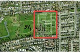
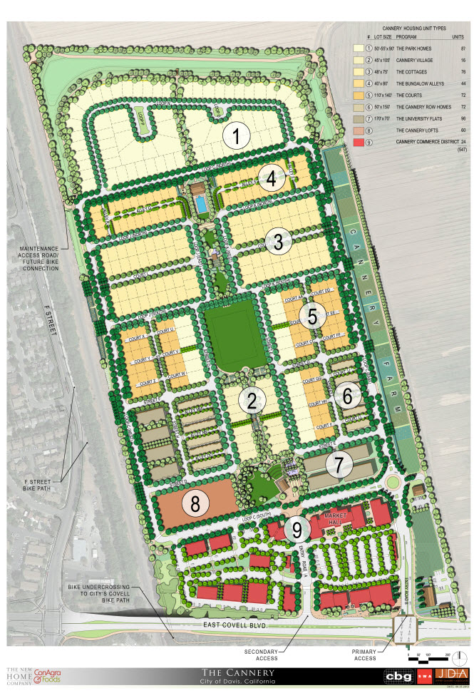
“The project proposes a mix of land uses consisting of low, medium, and high density residential uses; a mixed-use business park component; drainage detention areas; open spaces including greenbelts, agricultural buffers, an urban farm; parks; and a homeowner association neighborhood center on approximately 100 acres of land located at 1111 East Covell Boulevard, within the incorporated boundary of the City of Davis. The project site is the former location of the Hunt-Wesson tomato cannery,” staff writes.
ConAgra is the applicant for the planning entitlements. The New Home Company is acquiring the residential portion of the property and will likely contract with a builder of affordable housing for development of the multi-family affordable housing site.
The mixed-use areas will be developed by separate entities. The New Home Company is proposing to make a portion of the residential lots available to small builders and owner-builders. The urban farm is proposed to be transferred to the city; the city and the applicant team have been meeting with the Center for Land-Based Learning about design and program considerations for the farm and the ultimate lease of the farm to CLBL for their operation and management.
Because the site is currently designated for urban uses and not agricultural or open space uses, Measure J/R voter approval is not required. However, as we have noted previously, numerous entities and individuals have considered the option of putting the project up for a vote.
“The project includes 10-12 different residential product types, including the Accessory Dwelling Units (ADUs). Additional variety is provided through construction on lots sold to owner-builders or small builders. The project includes single-family attached and detached units, row houses, two condominium sites, and rental units in the mixed-use area. Overall density in the residential area is 14-15 units per net acre, not including the accessory dwelling units. Denser housing is located closer to Covell Boulevard and the Mixed-Use Area,” staff writes.
“The Cannery is planned as a mixed-use, multi-generational neighborhood designed to be consistent with the existing community character of Davis,” staff writes.
“The market-rate ownership units include a mix of housing types and sizes. The breadth of housing types was designed to reach the spectrum of buyers with a range of incomes and different lifestyles,” staff continues. “The inclusionary affordable housing requirement for the project, based upon the Council actions of July 2013, is 57.65 (rounded to 58) affordable units. (See Affordable Housing Plan, attachment 11). The applicant has committed to a minimum of 62 affordable units, composed of Accessory Dwelling Units (ADUs) and permanently affordable rental apartments.”
Affordable rental housing for small households, such as graduate students or single workers, is provided through the accessory dwelling units (ADUs) in the “Bungalow Alley” and “Cannery Village” subareas, according to the staff report, where “[a]ffordable rental housing for families will be accommodated through the 40-60 apartments on the ‘Cannery Lofts’ site.”
The project also strives to achieve accessibility, where “[t]he applicant is proposing to contract with the Eskaton organization to certify all single-family units through its Livable Design Seal of Approval Program.”
According to staff, the project will have “stepless entry and path of travel and either a bedroom and bathroom on the ground floor or a ‘Flex-Home’ option, with either stacked closets (to accommodate a future elevator) or wide stairway with electric power (to accommodate a future chair lift).”
In addition, “The New Home Company will offer both elevators and chair lifts as purchaser options for the homes. If not opted for at the time of purchase, the units will remain adaptable for future conversions to such systems.”
In March 2013, the Senior Citizen Commission reviewed the project proposal. The Commission found that the proposed Livable Design program and builder commitment is more than sufficient to meet the goals of the city’s guidelines for universal access.
The project includes a 15-acre mixed-use site along The Cannery’s frontage with East Covell Boulevard. The mixed-use site could potentially accommodate up to 171,270 square feet of uses and could accommodate buildings of two or three stories and employment opportunities for 600 to 850 jobs, but the current site plan shows less intensity in that portion of the development, staff reports.
They write, “The mixed-use area is intended to activate the neighborhood and provide a gathering place serving both residents and employees. It will be oriented toward the park, and the applicant is proposing to work with the City to program the area with concerts and other activities. The circulation network for the mixed-use area has been designed to accommodate street closures for special events.”
The project also includes an urban farm along the eastern edge, bordering Covell. Writes the staff, “The urban farm is designed to incorporate compatible agricultural production into the design of the neighborhood to increase direct contact with the local food system while supporting a new generation of farmers. The concept calls for the land to be improved and deeded to the city for lease to an organization such as the Center for Land-Based Learning. The applicant is working with CLBL to develop a business model that will provide economically-sustainable training opportunities for new farmers.”
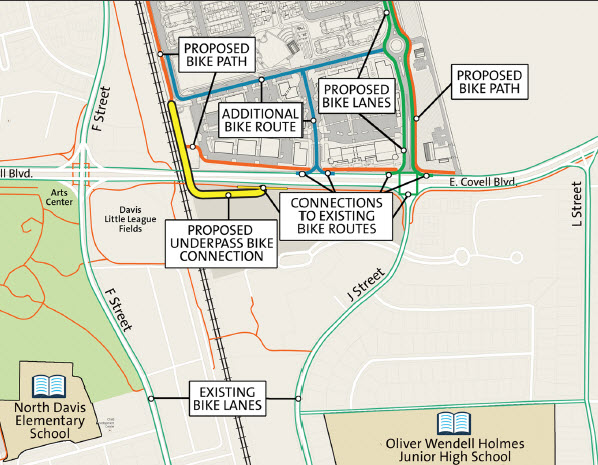
On April 4, 2013, the Bicycle Advisory Commission and Safety and Parking Advisory Commission held a joint meeting on the transportation network for the project. The internal circulation for The Cannery was not identified as a concern by Commissioners.
The biggest concern is the connectivity to existing bike paths and other non-vehicular modes of transportation.
Writes staff, “As an infill site with existing established development to the south and west, access to the site is more challenging. The railroad tracks are a barrier to the west, and access to the north or east would require crossing agricultural land in separate private ownership presenting potential challenges to the agricultural uses of the property.”
Staff notes that there is a future bicycle connection at the northwest corner for the Davis-Woodland alternative transportation corridor, should that be implemented by the cities and Yolo County. Future bicycle and vehicle connections to the east could be incorporated at the Covell Village frontage, the Loop C roundabout, or at the northeast corner of Loop C.
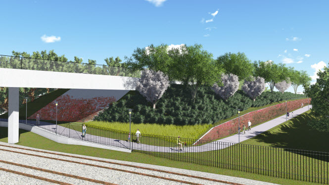
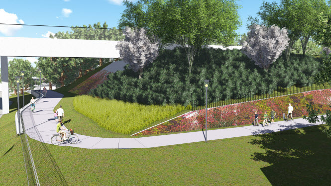
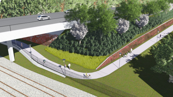
Staff writes, “The project description has been revised such that the preferred alignment for the off-site bicycle/pedestrian path connection is Option 1 (i.e., connection south of the project site to the pathway on the south side of East Covell Boulevard). Option 1serves to diffuse trips east and west, rather than direct all riders to the H Street Tunnel. It also provides a more direct route to destinations along Covell Boulevard (although west-bound cyclists are required to climb the overpass, which has a maximum grade of 8% at its steepest point for a distance of approximately 30-40 feet).”
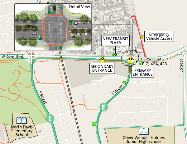
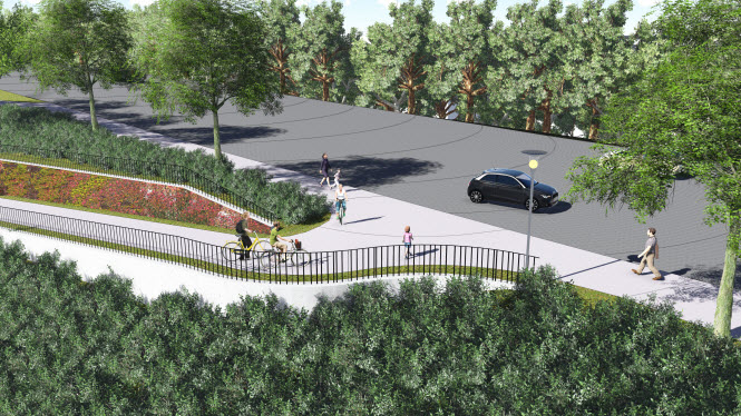
Staff adds, “The reconfigured J Street intersection will include elimination of the existing free right turns and integration of Class II bike lanes on all approach and departure legs. The signal will be responsive to bicycles and pedestrians. Cyclists crossing Covell Boulevard at the intersection will have direct connections through the bike lanes on J Street to routes to Holmes Junior High, downtown, and the campus. The following exhibit shows preliminary concepts of how the intersection could be reconfigured to improve bicycle and pedestrian connectivity.”
Earlier this year, the city council initiated the Covell Boulevard Corridor Plan effort. The goals of this effort are to improve the safety, appearance, and comfort for all uses in the area between F Street and Birch Lane, while creating a signature corridor that applies best practices in streetscape design.
According to staff, “Preliminary recommendations for the corridor plan are still being vetted at the staff level, and will need to be presented to the community for feedback and potential refinement before the plan is presented to the City Council for adoption.”
Concepts being considered include:
- Eliminating free-right vehicle turn movements at intersections to reduce bicycle/vehicle conflicts and improve bicyclist and pedestrian comfort;
- Completing the separated bicycle path along north side of East Covell Blvd (west of Pole Line Road);
- Improving the streetscape and providing gateway features at East Covell Blvd and Pole Line Road;
- Improving bicycle access on the north side of the intersection at Covell Boulevard and Birch Lane to enhance access for children to/from school;
- Improving air quality impacts from vehicle idling, traffic calming on the corridor and available gaps for traffic exiting the Oak Tree Shopping Center via signal optimization;
- Incorporating traffic calming as needed along the corridor;
- Improving the look and feel of the corridor via integration of street furniture, landscaping, and lighting, where appropriate;
- Identifying potential improvements to related bicycle and pedestrian facilities that provide connectivity to the corridor, such as J Street, Drexel Drive, the H Street tunnel, and Pole Line Road, north of Covell Boulevard;
- Preliminary evaluation of potential for additional grade separated bike/ped crossing between J Street and Pole Line Road;
- Potential transit stop enhancements along the corridor;
- Potential for buffered bike lane striping.
For additional information see the following Vanguard articles:
—David M. Greenwald reporting