Demographer Paul Mitchell did a presentation last night (the full set of his presentation slides are available on the City website) and explained that, while Federal law uses “majority minority” districts as the standard, the CVRA (California Voting Rights Act) only requires “ability to influence” – which he said could be as low as 16 percent.
He said that districts should be thought of as something “on election day” rather than “something that impacts every single decision and how you work.
“It does not determine how you govern,” he said. “The city can still work to achieve goals that benefit the city as a whole rather than the interests of any single district.”
He explained that the way they would operate would be based on census data – “who was here on April 1, during the last decennial census.” He explained that that count is of people, not citizens. That creates some interesting dynamics because, as his map shows, no one was living in Cannery, for example, in April 2010.
The notion of contiguous is important – the districts should not jump natural geographic barriers and any individual district has to be functionally contiguous. That could preclude a district that includes the two areas north of Covell Boulevard (far North Davis to the west and Wildhorse to the east), although he suggested they may be able to run it along Covell, connecting the two parts, and be able to justify it.
On Communities of Interest – mostly we are dealing with communities covered by the Voting Rights Act – Latinos, Asians, and African Americans.
The tricky thing, he explained, is that “while race and ethnicity and these protected classes are used as a way to observe the redistricting, we cannot draw districts solely with that criteria in mind.”
The other concept of Communities of Interest are: people living near an industry, Senior Citizens, Students, Downtown, Urban, Rural, Agricultural, Homeowners and/or Renters.
Mr. Mitchell explained, “It’s not just the people who are living here, it’s also how it relates to the city.”
The 2010 Census population was 65,622. He said the median population for a five member district was 13,124. He suggested that the numbers cannot exceed 10 percent deviation from that average (a high of 14,436 and a low of 11,812), and he said functionally they should make the deviation as narrow as possible.
He argued, “We have enough technical ability to draw districts that are extremely well-balanced.” Furthermore, the city will have to redistrict again in 18 months when the 2020 Census numbers are available, and thus the more they can do in this redistricting “could mean that you can have a less dramatic redistricting in the future.”
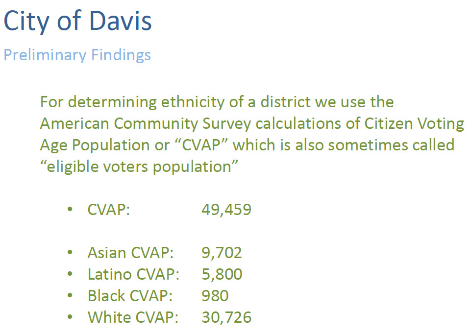
To learn about ethnicity, they use the American Community Survey calculations of Citizen Voting Age Population or “CVAP,” which is also sometimes called “eligible voters population.” CVAP counts the people of voting edge, which he called a proxy for eligible voters.
In 2010, the white population was slightly higher than 60 percent. As we know, that number now is probably between 55 percent and 50 percent, and that could affect things when the city has to redistrict following the 2020 Census.
The Census Block Group information in the graphic below rounds the numbers in order to draw rough districts.
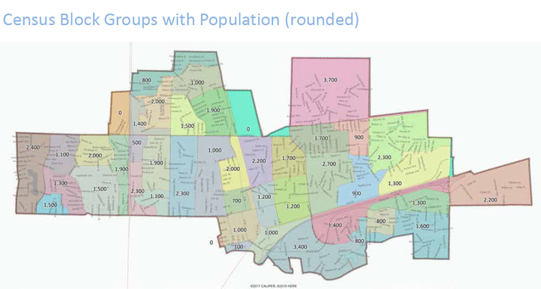
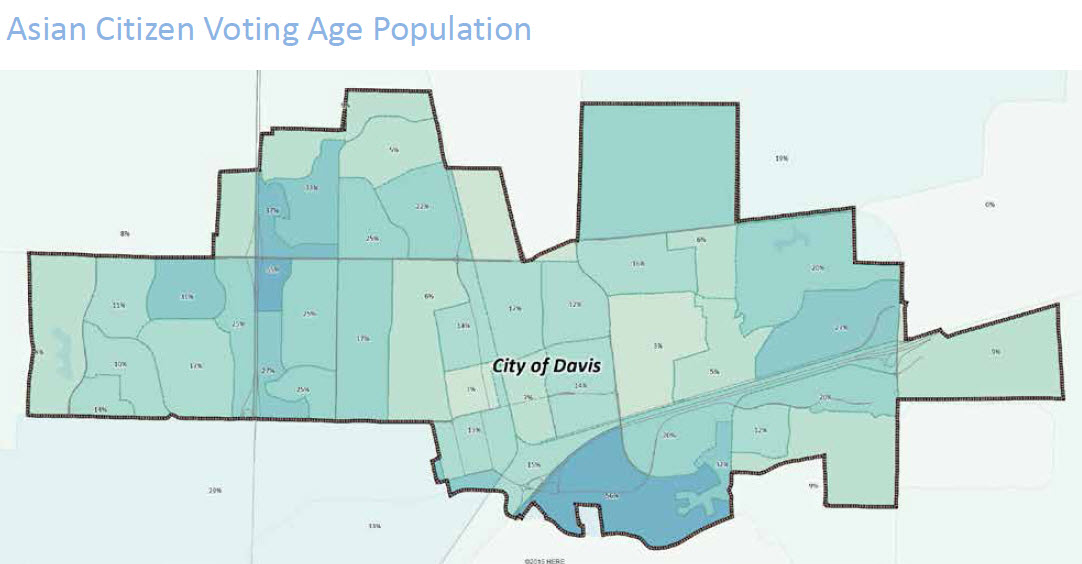
Looking at the Asian and Latino Census block groups in the next graphic, and he noted that there are actually two census blocks that are majority Asian – though they are not geographically close to each other.
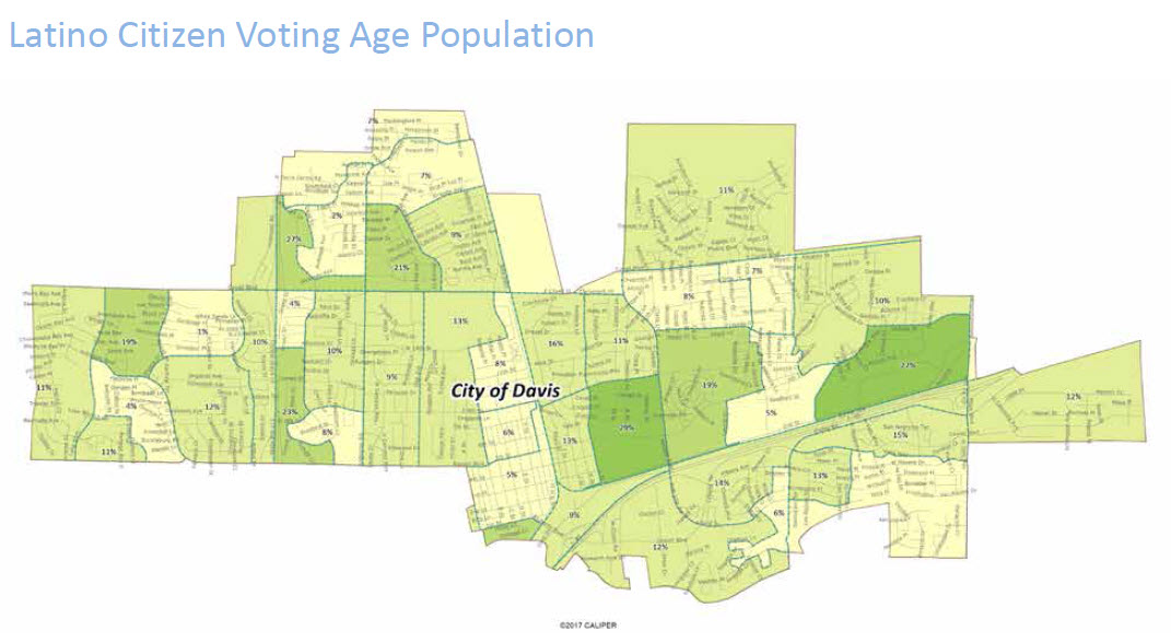
Similarly, he pointed out that the Census Blocks with the highest proportion of Latino CVAP (the darker areas in the graphic below) are geographically dispersed through the city.
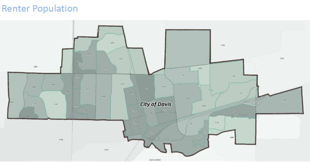
He noted they can also map the renter population – which he said could also be a Community of Interest.
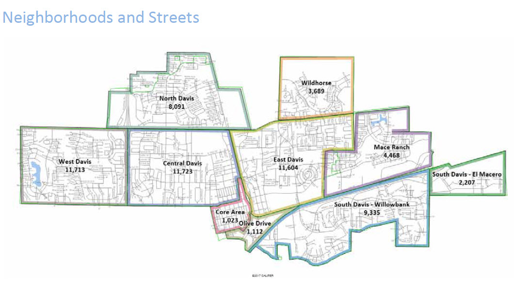
The neighborhoods are smaller than the district size, but can start to become the basis for some of them.
Mr. Mitchell indicated that if the council was interested in considering seven districts, they would likely provide additional maps for community discussion.
In a question from Councilmember Lucas Frerichs, he was asked how to account for the fact that there were no people living in Cannery in 2010, but there are now. “How do you account for that?” he asked.
“Essentially you can’t,” Paul Mitchell responded. He noted there are municipalities who decide to over or under populate districts on this basis, but he said “that ends up violating a higher order criteria (equal population). You’re in a position where you really don’t have a lot of freedom to put an asterisk on the equal population number.”
He did suggest they could put those districts up in 2022 instead of 2020, so they can redraw and rebalance the districts before someone is elected from there.
“There’s no way to get around the equal population requirement,” he said.
Councilmember Will Arnold asked about the contiguous requirements.
Paul Mitchell said the requirement is “functionally continuous.” On a map, things could look contiguous, but if you cannot get from point A to point B and stay in the district, it is not considered contiguous.
“If you need a canteen and a map to get from one side of the district to another, it’s not really contiguous,” he said, noting the issue is more common with legislative districts, which often include mountain ranges as geographic barriers.
One map suggestion was everything north of Covell Blvd. be together. “Yet there is a big gap,” Will Arnold said, noting that was intentional as the voters voted down Covell Village. He also pointed out the numbers for those two neighborhoods work out even if the they are not actually contiguous.
Mr. Mitchell responded, “In order to make it contiguous, you would definitely have to follow Covell Blvd. and join those two together. You would have to have a really really strongly developed rationale to join those two together.” He then described a district in the LA area that is connected by a beach, but there was a rationale for it – the rationale had to do with the LAX airport and concerns about noise issues associated with the flight paths into and out of LAX, which the non-contiguous neighborhoods shared in common. That description begs the question, “What do the Far North Davis neighborhoods and the Wildhorse neighborhoods share in common?”
—David M. Greenwald reporting


I suggest folk watch the streaming video of the presentation, and the follow-up exchange with CC members & consultant/staff.
The VG account is pretty good (B+/A-), but I recommend folk who are really interested in this, view the video. I was impressed.
Bill, I think this is one of David’s best articles over the many years of the Vanguard. I think B+/A- is an undergrade. I would give it a straight A.
I don’t think it’s one of his best, but it does capture what the presentation pretty well.
It’s not clear to me if that was a back-handed compliment or a back-handed insult.
Are Indians, Asians, in this accounting?
What about people who choose to voluntarily not identify?
Where are American Natives in this?
After all, this was once all their lands, not long ago, historically speaking.
Perhaps one big district, all Patwin?
That may be the only real way to make this actually ‘fair’ from a race point of view.
What about multi-ethnic/racial?
I know a lot of folk who are Asian-White, Black-White, Latinx-White, and one Asian-Latino. How are those figured into the ‘calculus’?
Alan, am just adding a question to your valid questions.
Bill and Alan, since the Census gives us all the opportunity to self-identify, each of us controls the answers to your respective questions in our choice of what we provide as responses to those self-identification questions. Some of the questions have evolved/migrated over time as the 10-year periods have unfolded. If a Census respondent chooses to not answer and question about race, or any question about color or any question about language, then the data of their submitted record would not have any information that would cause them to be counted as a member of a protected class.
Regarding Bill’s multi-ethnic/racial question, I believe the following language of the Section 4026 (d) of the CVRA addresses all those groups, because they are all qualify under the “members of a color” designation. American Natives are also considered to be “members of a color, as well being distinguished as “members of a race” and “members of a language minority group.”
Another point that seems to get missed here – we don’t need to know the exactly number of each race/ ethnicity. There is probably some sort of an error term involved. But a ballpark total is likely sufficient.
That’s helpful, MW.
So Matt… if someone declines to state, is the default “white”? Or something else…
Thanks for the clue on “self-identified”… have to figure out how I’ll choose to ‘self-identify’… I could have some fun with that… I’ve known Marshall’s of several races, mainly black or white… or both.
Bill, I don’t know the answer to your question, but my personal opinion is that the answer you are looking for is in the data of each submitted record, which would not have any information that would cause the respondent to be counted as “white” any more than cause them to be counted as a member of a protected class.
I was doing some voting history research the other day that resulted in the graphic below. The data is from Pew Research, and if you add the percentages in each category, they do not add up to 100%. The remaining percentage that brings the total in each category up to 100% is for those voters who “declined to state.”
https://www.davisvanguard.org/wp-content/uploads/2019/09/Screen-Shot-2019-09-04-at-7.58.35-PM.png
d*ng, did I miss another exciting interlude? I really must check every 5 minutes so I don’t miss anything.
Not really.
Certainment. Accusations of potential racism, other accusations, by someone who needs mirror time… normal, normal… And, Mr Alan Phelps, this post will self destruct in a few minutes… if not purged earlier…
D. Greenwald: “He did suggest they could put those districts up in 2022 instead of 2020, so they can redraw and rebalance the districts before someone is elected from there.”
That actually sounds very sensible, because the city council districts (even the DJUSD trustee districts) could also be fine-tuned with the 2020 census. But it seems like the current framework might not allow for it.