By David M. Greenwald
Executive Editor
Davis, CA – When DiSC 2022 went before the Planning Commission a few weeks ago, the commission was supportive of the project but they had a series of recommendations to strengthen it. The applicants took those recommendations to heart and made a series of changes—the most substantial was relocating several of the commitments in the Baseline Project Features and committing to the construction of a grade-separated bicycle and pedestrian crossing of Mace Blvd.
They also agreed to construct a bicycle connection from the west side of Mace Boulevard, north of the Nugget Headquarters, westward to the City’s existing trail system that runs between Lake Alhambra Estates and Harper Middle School. Committed to planting no less than 1500 trees. And eliminated the ability to use on-going funding sources to meet affordable housing goals.
The big one perhaps is the bicycle and pedestrian crossing.
“We’ve always wanted this connection and we never doubted that it’s an important connection,” Dan Ramos, the project manager, told the Vanguard on Friday.
The concern was how they could construct it up front with the project because, as Ramos pointed out, “it’s a pretty big burden up front.”
He said, “In the negotiations with the city, especially (Mayor) Gloria (Partida) and Dan (Carson) (members of the subcommittee) and they were very clear that they felt it was so  important that that commitment be made.”
So he said, “We will commit to doing it.” And he said, it will occur “during our first phase before we start a second phase.”
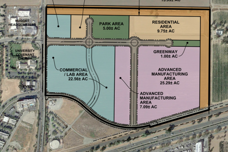
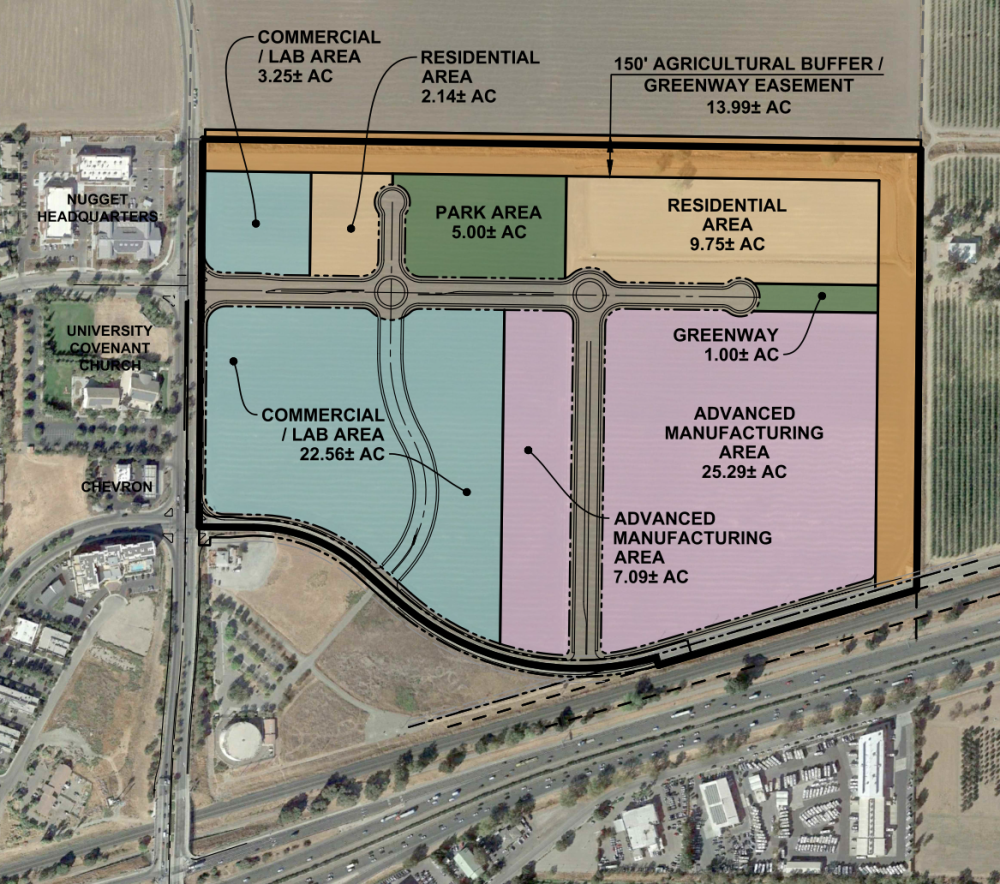
The project, now at 102 acres, has reductions not only in the size of the project but impacts on traffic and parking.
Ramos previously noted, “Overall traffic… is cut by 55 percent.”
The FAR for the project site will be 0.71—exceeding the 0.5 FAR minimum threshold by the city in 2014 but a slight reduction from the 0.93 FAR of the previous project.
Parking spaces have been reduced from 5858 spaces to 2050 in the current configurations. With the reduction of the Office/R&D/Supportive Retail from 1.6 million sf to 630,000, the parking space allotment there reduces from 3848 to 1050.
According to the EIR, “The parking ratios used for DiSC 2022’s commercial components are consistent with those planned in the previous DISC project, which represented a considerable reduction from the parking requirements set forth in Davis Municipal Code Section 40.25.090. Similarly, at a ratio of 1:1, parking associated with the project’s residential units is proposed at a standard less than the City average and in a manner that reflects the walkability of the project site and current trends in personal transit preferences.”
The time horizon for the reduced project has been decreased from over 20 years to 10 to 15 years.
The build out would occur in two phases. Phase 1 would “consist of approximately 50 acres and would include 550,000 sf of innovation building space, 80,000 sf of supportive retail, and up to 275 residential units, comprised of single- and multi-family housing types and estimated to consist of approximately 183 multi-family units and 92 townhouse units. Construction of the residential units would be timed to slightly trail the commercial development, so that jobs are created on-site prior to offering housing.”
It continues, “Consistent with the previous DISC project, housing would be permitted at the DiSC 2022 site at a ratio of one unit for every 2,000 sf of nonresidential development (supportive retail excluded).
“The objective continues to be to time the availability of the homes to be concurrent with the creation of jobs, thereby maximizing the likelihood that on-site employees would occupy the units,” the EIR notes. “Such an approach would achieve the greatest environmental benefit of including housing within the project site.”
According to a new traffic analysis by Fehr & Peers, the DiSC 2022 project would generate 11,284 net new daily vehicle trips, with 1,052 trips occurring during the AM peak hour and 1,155 trips occurring during the PM peak hour.
This again marks a considerable reduction from the nearly 24,000 projected trips generated by the original DISC project with about 2200 during the AM peak hour and nearly 2500 during the PM peak hour.
On Tuesday the project goes before the council where staff is recommending that the council approve the project, which would send it back to the voters.
The project rejected by voters in 2020 by 52-48 margin came back last summer as a reduced size but without that bicycle and pedestrian crossing that was so crucial, given the congestion on Mace Blvd. A number of people indicated that that was a make or break issue for their support for the project and it was a focal point of the Planning Commission recommendations.
Ramos confirmed that this would be in the baseline project features (see page 52 of the staff report – B52 and B53).
“The DA requires the developer to construct several new bike/pedestrian related improvements, including providing the land for a grade separated undercrossing of Mace Blvd. This will connect the 1.5 miles of publicly accessible bike/walking trails within the DISC 2022 project to a future trail along the inside of the Mace Blvd curve,” the staff report notes.
“The developer will also be responsible for the construction of the separated grade crossing across Mace Blvd and will construct a bicycle connection from the west side of Mace Boulevard, north of the Nugget Headquarters, westward to the City’s existing trail system that runs between Lake Alhambra Estates and Harper Middle School,” it continues.


Accompanied by,
The latter is a huge commitment, and, an appropriate one…
The biggest impediment to my giving a favorable vote on the project, has been resolved… there were, and are, others, but with additional information, those may be resolved as well…
What other concerns do you have?
Will ‘pass’ for now (in detail), but wanted to acknowledge your question… mainly, they center on the most boring of areas, technical issues… hey, I’m an engineer… I focus on flood plain/drainage, utilities, and traffic/alternatives… silly me…
Your question is interesting… was it for clarity, or to look for a ‘wedge issue’… unclear… I have provided a clue as to the answer for your question… will you answer the question, “Why do you ask?”
I seriously doubt you will answer my question… I might be incorrect… we’ll see…
Another question for you… “Do you support the proposal unequivocally, or do you oppose the proposal unequivocally?” or somewhere in between which is the ‘space’ I’m in…
Ball is in your court (yes, played varsity tennis)… again, I expect no response…
Considering you didn’t respond to CR’s question, I’m not sure the ball is in their court. Not that not responding isn’t a legitimate non-response, just pointing out the location of the ball.
Was just wondering
’twas becoming clear the pressure for this was coming from multiple directions, not just Sir Alan Miller. I believe this could make the difference in getting the vote pushed over the line. I promised I would vote for DISC II if the undercrossing were in the baseline features and being an it of my word, I will be voting for DISC II.
Ramos talked to me before the DISC I vote and I was convinced of the developer’s sincere desire and intention to build the under-crossing when they could. But, having been disillusioned by the Trackside reversal (a gov’t entity can interpret away any planning document or promise and call a kumquat a kangaroo if ‘things are different now’), I was thus concerned at how many years of decades it would be before the under-crossing were actually built – as it is needed when DISC opens. Thus this time I insisted on this being in the baseline features (for my single vote – and my support), this being – apparently – binding, unlike most so-called commitments — as we’ve seen in Cannery, Design Guidelines, list goes on . . .
I will be keeping an eye on the design, mainly the approach and connections to the City trail system. I do encourage the developers to drop the idea of routing County buses off Mace into the development at a ‘transportation center’. With so many last-mile solutions today to pubic transportation, the wise trend is toward streamlining and simplifying bus routes to speed them up, and away from the traditional ‘loop to everywhere’ planning. Having the 42A & 42B stop on each side of the ped-bus tunnel allows people to cross under Mace. This should then connect on the east side to a high-quality bike-ped-ebike-scooter path direct into the core of DISC.
The UCD-Downtown-Amtrak-2nd.Street-DISC shuttle should of course have a joint stop with YoloBus and CAN/SHOULD continue into the center of DISC, because unlike YoloBus, it terminates there. [Though, perhaps in winter the shuttle could continue six miles south to the migrant/homeless center and solve that problem as well — nah, just pulling y’all’s legs] I realize the shuttle isn’t in the baseline features which I’ll forgive as operating costs are a challenge – but I hope the City/County/developers find a way, as this shuttle is an key route.
Perhaps this shuttle could have bike racks and continue over Mace to Nugget as a partial solution to TE’s valid concerns about the difficulty/hazard of bike/peds to get over I-80 from DISC/Target to Nugget. Regardless, TE is quite correct about the need to improve this overpass to allow peds/bikes safer access. This is a difficult challenge – perhaps a 2-way bike-track on the west side? Those highway onramps preclude ‘friendly’ interaction with auto traffic. Maybe F&P can be tasked with a proposed solution — as a new ped/bike bridge adjacent to the Mace overcrossing isn’t even on the radar.
I am pleased that DISC will include a high-density housing component on the east periphery. Unlike the old thinking of no housing, I believe this will help with Davis housing needs. I don’t for a minute pretend that only DISC workers will live here, but at least they can. Having the housing component for DISC is a positive in my book.
As a developer once said to me in introducing himself, ‘I was told if you want to get something built in this town, you need to talk to Alan Miller’, to which my response was, ‘Who the héll told you that S ???‘. While my ego may have loved that fallacy, I am here today to say that DISC and team Ramos you have my June 2022 vote and my support. Thank you for including the Mace Bike Undercrossing in the baseline features.
Hi Alan,
Buses will no longer be coming into the project for pickup and drop-off. The transit plaza has been relocated along Mace so they just pull over along Mace. Given the project’s reduced size, it made more sense to not have the buses deviate from their routes.
The DiSC, 2nd Street, Amtrak, UC Davis shuttle is still planned on being funded through DiSC, so would still be up and going if this project passes.
Thanks for your support of DiSC.
WS, these things are good to hear (no interior transit plaza & shuttle to be funded). I’m not sure how you locate a ‘transit plaza’ along Mace since it would have to be on both sides (unless it’s in the middle with stairs down to the tunnel). There should be a stop along adjacent to the ped/bike tunnel for easy access for peds without xing Mace. I’d like to see the transit plans and glad to add my 2¢ on the route details (for which I will charge 2¢) as a professional transit planner.
Congratulations – the crossing has now apparently returned to the proposal that already lost, once (which had already included the crossing). (Sort of like how McDonald’s periodically brings out the “McRib”, as I recall.)
In any case, the proposed underpass is proposed on the north edge of the development (last page in the link, below). Seems like it would be better if closer to Alhambra, and doesn’t appear to be that convenient for those attempting to ride from town to locations beyond the development (e.g., using Road 32A, to continue toward Sacramento). So, I’m not sure why anyone not associated with the development would care all that much about it.
But more importantly, one can see from the diagram (in the link below – last page) that it is really intended to serve the “missing half” of DISC, in the future. (The site that will no doubt be proposed for housing, adjacent to the housing that’s already proposed on the north side of the current proposal.)
http://documents.cityofdavis.org/Media/Default/Documents/PDF/CityCouncil/CouncilMeetings/Agendas/2022/2022-02-01/06-Davis-Innovation-and-Sustailability-Campus-2022.pdf
The document also includes the following text:
So clearly, the developer is seeking other parties to help pay for it – including the “other half” of DISC (and/or, the government).
Page 109 of the document notes the following, as noted in the article above. So, as long as the first phase is not declared “complete”, the bicycle underpass apparently does not have to be completed:
It might also be noted that “slightly trail” is not defined, above.
The proposal that lost was twice the size. Just saying. Not the exact same project.
Also if the northern part comes back, that would take a separate approval. Not sure why that’s such a big conspiracy theory for all the no-ers.
It is either naive or dishonest to suggest that another proposal won’t be forthcoming, on the “missing half”. The funding for the underpass already anticipates it. (I assume it’s an underpass rather than an overpass, but it’s not clear.)
For one thing, there will be increased RHNA housing requirements, if the commercial component is successful.
(But honestly, it seems that there will be a serious reassessment before proceeding to Phase 2, regardless. And if they don’t fully-complete Phase 1, it appears that they don’t have to provide an underpass.)
If I’m not mistaken, the “landing” for the proposed crossing is already on the “other” half.
I suspect that the northern half will be exclusively-proposed for housing, adjacent to the housing that’s already included on the northern half of the current proposal.
With a grade separated bike crossing it will at least alleviate some of the problems that bicyclists will have to deal with on the MACE MESS.
Yes… we know the needle on your record player skips to the same point of your music.
For brevity, just use a #, like 104… we’ll know what you mean. The ‘driver’ (pun intended) of the “Mace Mess” is the South Davis folk, insisting on driving at their chosen times, some demanding Mace/Cowell intersection changes, to ‘protect’ everybody from everything, compounded by the Waze thingy, where folk divert in Dixon to same maybe 4 minutes in their travel time…
I choose my times to use that corridor… have never had a problem… so, not my problem…
But you seem to have another ‘agenda’ related to DiSC… your (and others) reactions remind me of a situation I dealt with in my professional life… looking to site a 20 bed battered women’s shelter, the locals protested based on ‘traffic’… their real reason lay elsewhere, but they couldn’t admit it…
So if it’s not ‘your’ problem it’s not a problem? Others might feel differently…
What is the root cause of the ‘problem’… you have not pointed to any credible cause to this point… you’ve complained about your inconvenience at certain times of the day… that’s not a life/death issue… yet, you tend to portray it as such…
I believe, if you can avoid a problem, it is no problem… empathy I have, for those who try to look at their behaviors, and make changes, to avoid problems… and still have problems… I have little sympathy for those who insist “my life should be perfect, on MY terms”…
We’ll just agree to disagree on ‘mind-sets’ (?)
So those trapped in the MACE MESS should stop complaining because life isn’t perfect?
Tell them that…
Isn’t Mace Mess, the portion of Mace south of the freeway, so therefore completely unaffected by this project?
Believe me the Mace Mess is on the other side of the freeway too. Take it from a guy who has had to often times wait 20 minutes or more to get from the Mace curb to Guadalajara’s Restauarant.
Unless someone is retired, works at home, or doesn’t have school-age kids, who gets to choose when they use a corridor?
You, WM, are the King of Implication — yet I often don’t know what you are implying. A women’s shelter would neither generate much traffic nor have ‘undesireable’ persons (unlike a homeless shelter, where the tenants are often meth addicts). And considering the location of the women’s shelter is secret, how would anyone know where it was being proposed?
LOL, well it sounded good anyway.
They knew… not sure how… one of the PD liaisons to the Planning Department was one of the most vocal ‘citizens’ @ the public hearings… blaming traffic, as he could not come out and say what the real issue was to him and his adjacent neighborhood… connect the dots?
If it’s the one I’m thinking of, I kind of remember covering it. Can’t find the article so far.
The trap was set likely shortly after “DISC 2020” was defeated by voters. When the developers of this peripheral sprawl – or I’ll be nice and call it West West Sacramento – were planning to re-introduce it last year for a vote this year – they realized that a key demand was a grade-separated crossing of Mace. So they removed it from the BaselineUCD Campus Travel Survey 2019-2020 (pg. 30) – By bike, DISC is just over four miles from ARC, a central point on campus when considering agricultural facilities. This distance has about a 10% modal share for cycling, and includes mostly students, many who don’t have their own cars. Features… fully-intending to agree to do it as a concession.
Back story
The City Council-approved Street Standards (2016) don’t mention e-bikes at all. What this means is that the width, curvature, and proper siting of infrastructure that would optimize the use of e-bikes – in particular the Type 3 variant that has assistance up to 28 mph – is totally missing in Davis, or more immediately in concepts, plans as well as development agreements and baseline features in current and near-future projects.
To address this, over two-and-a-half years ago when I was on the Bicycling, Transportation and Street Commission (BTSSC) I got support for adding an item to the long range calendar which would address it; this first appeared on the LRC in September 2019, with a possible date of December 2019 for the agenda. (It is abbreviated somewhat erroneously as “intersection design guidelines / standards”). It has been pushed back repeatedly since then, and the BTSSC did not support forming a sub-committee about it during 2020.What this means is that significant concepts and projects which could alleviate transportation problems, such as Reimagine Russell, the new-ish Class I multi-user path on the south side of Russell (chronically and clinically-referred to as a “bike path) or smaller projects all over the city are not future-proofed for the increase of modal share for cycling we desperately need to improve everything from climate impacts to conviviality to fitness to transportation crashes. Our city is simply too large now in size to have a significant modal share with “acoustic” bicycles. Not convinced? Look at the low bike modal share from peripheral areas of town in the UCD Campus Travel Survey, which shows low share even for people with campus destinations where car parking is not always convenient, and not fare-free. It’s not hard to extrapolate – necessary, as the City has essentially refused to do its own counts for years – that almost no one regularly rides from Mace Ranch or some other peripheral areas to Downtown for a coffee or beer – sort of the most normal thing in the Universe in a bicycle-branded cycling city.
However, as we can see from the example above, the faster type of e-bikes are quite expensive. I’ve seen nothing lower than just over $3,000. Though important – or all – major arteries in Davis – should be optimized for this type of bike – the idea is not only to optimize for them but make safe for all users, including on acoustic bikes – it cannot mean that this type of bike should be essentially required to live here and enjoy the purported high quality of life. Infrastructure optimized for fast bikes is also a significant improvement for all bikes, as it’s direct, requires a minimum of stops, is not shared with motor vehicles… or pedestrians and dogs.To be more precise, the goal should be the 15-Minute City. This is a relatively new standard or classification of a very, very old sometimes organic strategy to make key locations in a city within 15 min from anywhere else, for all means of transportation. This seems to also serve as a kind of proof of the bicycle modal share results in the Campus Travel Survey. It’s definitely something that should be part of our new General Plan, or even worked on earlier by a joint Commission process (BTSSC, Planning… perhaps Natural Resources and Social Services…). I would argue that it should also be about effort, so a 5 or perhaps 7-minute walk is the equivalent of a 15 min bike ride. I’ve said that if kids can’t walk unaccompanied 5-minutes from where they live to buy ice cream cones, it’s a failure (and that’s just one example, a single ice cream place or a truck at DISC doesn’t make it sustainable.)
It’s also quite important to be reminded that the City of Davis has for over four years not had a senior civil engineer with a transportation focus. Many projects have gone forward – sometimes to completion, often with significant flaws – without the benefit of this experienced and wise counsel.
The Planning Commission meeting earlier this month…
At the Planning Commission review of Disc 2022 – and early this morning – I was actually quite impressed by the comments from multiple Commissioners regarding negative transportation issues of the planned project, and even the general discussion about its unavoidable impacts and uncertainly of benefits from transportation demand management… well, at least earlier in the discussion. Commissioner Shandy was particularly right on with her criticism of planned widening of Mace – presented by the developer as a kind of unquestioned religious observance – contradicts claimed benefits for people cycling and walking. There were other positive and thoughtful comments by a majority of Commissioners.I knew that the grade-separated crossing of Mace was a kind of sneakily-hidden prize and tried to point out in my sort of sloppy recorded comment that that a safer crossing of Mace would not on its own make DISC 2020 excellent for cycling (this is better than “cycle-friendly”), because of distance from Downtown and places further west, and besides that, safe crossings directly to the south along Mace across 80 would cost many millions and be very complicated (and at least in my head I know that Caltrans District 3 and the Yolo County Transportation District have withdrawn the earlier plan – it was supposed to be built first! – of a new bike and ped bridge across the Bypass as part of the I-80 Managed Lanes Project.)
The Trap is Sprung
Though it was fully-intended to be a positive thing and I will give credit to Commissioner Shandy, the discussion and lead-up to a vote turned sour when she proposed that a grade-separated crossing of Mace and a Class I trail across the undeveloped land south of Harper Junior High would make her feel better about the planned Mace widening and other traffic impacts. She suggested nothing about safe cycling and walking connections to other places, such as the Nugget and popular restaurants across 80. But the problem is that, for example, the area planned for housing at DISC 2022, on the north and eastern side of the project area, is more than 15 minutes away by bike from Downtown and at leat 20 to 25 minutes away from the UC Davis campus that is the raison d’être for DISC 2022! Moreover, the route has almost no optimized cycling infrastructure the whole way (varied from local streets to arteries, no protected bike paths, lack of priority at stops, etc… there is no proposal for any of this in any proposed development agreement or baseline features). But mainly it’s too far by bike… never mind walking! Most of the time people – with free or with un-bundled parking – will take I-80 between campus and DISC, even more so to many facilities etc on the west side of campus related to agriculture. I-80 is such a fantastic route much of the day that nothing can compete with it, including shuttles and express buses, which I am sure will at best have a tiny modal share. This creates huge challenges for any development more than 15 min away from key locations, and it means simply that they should not even be considered. (Oh, wouldn’t it have been great if staff were directed to work on the General Plan and told the developers that there was no capacity to work on stuff that would very likely be in violation of a progressive outcome for it?)So the Planning Commission recommended the two elements mentioned above that are supposed to address problems on Mace to the City Council. The developer’s plan worked perfectly: Carson and Partida demand and got the crossing in the DA.
But again, even with everything promised (e.g. shuttles, TDM) and not promised (e.g. e-bike-optimized infrastructure) there’s still no place for DISC. Still no way to successfully do something better than I-80 via private vehicle for anything but a minority. There’s really nowhere to walk to from DISC. Hopefully the voters will see through this ruse and others and reject DISC 2020.
Afterword
I am all for more housing – for all income levels, but with a significant proportion below market and lower income – and workplace and related development in Davis. I have never said I was against these things in any local discussions, for example in the Davis Vanguard. But they have to be infill, they have to be on greyfields such as parking lots, industrial areas along 5th St – not only the PG&E yard – and in the eastern side of South Davis and other areas much closer to Downtown and especially for what DISC 2022 purports to be about much closer also to campus. With electric shuttles on fixed routes, optimized cycling infrastructure, a new connection across 80 around L St., mixed-use above (existing) parking lots and so on many if not close to all of the actual benefits of a project like DISC 2022 can be realized. It’s not impossible, it’s not rocket science, it simply requires conviction, creativity and less b.s. and false claims about sustainability. Hopefully Council, Commissions… local media… and organizations such as Bike Davis and Cool Davis re-direct the citizenry towards an alternative to DISC or a truly sustainable version of it… closer to and integrated with the City of Davis and the UC Davis campus.
Note: This was adapted from an earlier version where I precisely predicted the moves of the developer and the Council sub-committee subsequent to the PC meeting.
[In the tone of ‘Get a Room’]: Write an article!
Todd did indeed “call it”, regarding the return of the “McRib”. Though it still seems to be in the “wrong” location, for existing Davis residents to utilize. It’s in the perfect location for the “other half” of DISC, however.
By the way, “planners” now consider Yolo county part of the “mega-region” (which includes the Bay Area). While noting that folks are moving out of the Bay Area, to sprawling-areas. (One would think that they would assign a “negative” RHNA number to parts of the Bay Area, but they’re not doing so.)
And since government officials are seeking to accommodate this (via government funding – as noted in the video), this seems to be the opposite regarding the effort to densify and limit both sprawl and greenhouse gasses. Not to mention the poor schmoes who will get priced-out, locally.
See link to short video, below.
MSN
So he said, “We will commit to doing it.” And he said, it will occur “during our first phase before we start a second phase.”
The commitment to “doing it” is a step in the right direction. Having that commitment in the Baseline Features is also a step in the right direction. That leaves two additional steps to clarify (memorialize in the language of the Baseline Features) (1) the timing of the completion of the construction of the tunnel, and (2) the funding of the construction costs (again memorialized in the language of the Baseline Features).
The timing needs to be (in my opinion) that no construction of any residential units can be commenced until the construction of the tunnel is completed. The language should forbid the City from issuing any building permits until the construction of the tunnel is completed.
the funding of the construction costs needs to be explicitly included in the Baseline Features, including how cost overruns will be apportioned. The DISC Team should be explicitly responsible for the construction management of the tunnel construction. That will avoid ex-post-facto finger pointing.
Hmmm . . . good point MW. Perhaps the timing of my yes vote, as in whether it’s a yes before or after the election, will depend on the clarity of the understanding of the timing of the tunnel.
I thought they committed to doing that before the start of the second phase?
I believe that is not good enough David. That commitment could mean the tunnel doesn’t happen for five or more years, and puts all the residents in Phase One at risk of being killed when crossing Mace.
It needs to be in Phase One and be completely constructed prior to the issuance of any residential building permits.
the other reason that needs to be the timing requirement is that the funding of the tunnel construction is like the Pillsbury Dough Boy right now … very soft and squishy. Problems/disagreements over the funding of the tunnel need to be eliminated prior to the issuance of any residential building permits. That needs to be in the Baseline Features.
one need go no further back in history than Mace Ranch to see how the timing of infrastructure construction can be massively delayed … and Ramos was the developer in that instance. Plus anyone who is paying the annual Mace Ranch CFD payment knows who got stuck paying the bill. It wasn’t the developer.
Thanks for clarifying.
Frank Ramos was the developer of Mace Ranch, father of Dan Ramos who is the developer of the proposed DISC project.
Don, fool me once shame on you, fool me twice shame on me.
Frank and Dan share the same two-story West Sacramento office. The last time I was there Frank’s office was upstairs and Dan’s was downstairs.
Another perspective…
Timing…
What we were often faced with for projects that required major developer expense, in addition to the basic infrastructure… this affects the bonding, security they are able to post, as well as the financing for the improvements… you have to convince the BANKS that they pencil out as far as cashflow for the project…
So what we did, when necessary, was write into the DA’s and/or Subdivision Agreements (that is where the ‘rubber meets the road’ at a very specific level), is allow some measure (varied by 15-25-30%) of building permits to be issued, but had a lower %-age (sometimes 0%) of Certificates of Occupancy issued, until the required improvements were in place, or were very close to being completed (weeks)… worked fine… developers could convince the banks, City still held the ‘hammer’, developers could sell, enter into contracts for those buying the lots. Same could be done as to sq. ft-age of non-res.
The concept of 0% building permits issued until everything is complete, in the real world, is not realistic, when you consider banks, developers and buyers/occupants…
Not sure if current folk in the City staff are aware of that win-win-win strategy… the key is issuing certificates of occupancy… no CO, no impact.